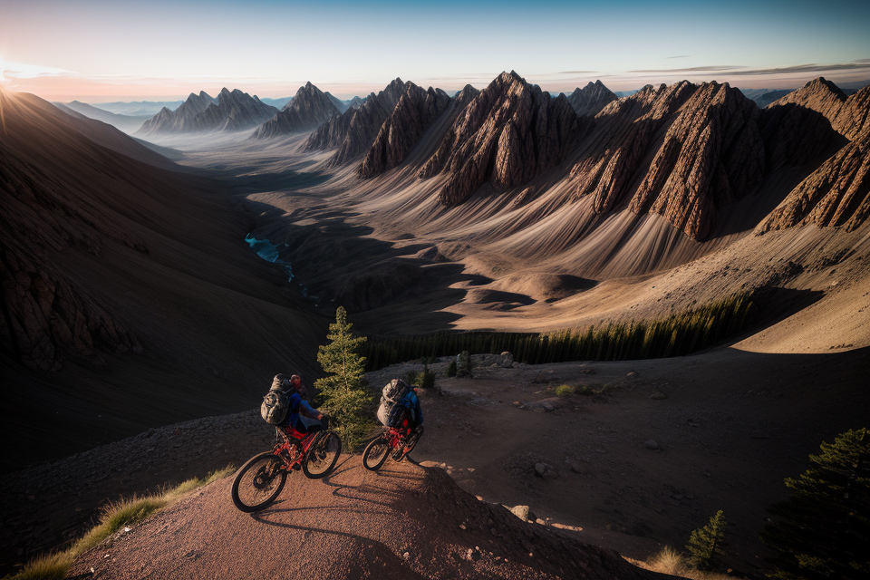
Bikepacking is an exhilarating outdoor activity that combines the thrill of cycling with the freedom of camping. It’s a great way to explore new trails, connect with nature, and challenge yourself physically. But how much distance should you aim for in a day of bikepacking? The answer varies depending on factors like your fitness level, the terrain, and the route you choose. In this article, we’ll delve into the average distance for bikepacking a day and explore some of the best bikepacking routes around the world. Whether you’re a seasoned cyclist or a beginner, this guide will help you plan your next adventure and make the most of your time on two wheels. So, gear up, and let’s hit the trails!
The average distance for bikepacking a day can vary greatly depending on the individual, the terrain, and the route being taken. However, a common goal for many bikepackers is to cover 50-70 miles per day. Some more experienced or fit riders may aim for up to 100 miles per day. When exploring the best bikepacking routes, it’s important to consider factors such as the physical demands of the route, the availability of camping and resupply options, and the potential for inclement weather. It’s also important to listen to your body and adjust your pace accordingly to avoid burnout or injury. Ultimately, the most important aspect of bikepacking is to have fun and enjoy the journey, regardless of the distance covered each day.
Understanding Bikepacking
What is Bikepacking?
Bikepacking is a unique and increasingly popular form of cycling that combines the physical and mental challenges of long-distance cycling with the freedom and flexibility of camping and exploring the great outdoors. It involves carrying all the necessary gear and supplies on one’s bike to allow for multi-day trips into remote areas, often with the aim of experiencing and connecting with nature, and discovering new and exciting landscapes.
In essence, bikepacking is a combination of bicycle touring and backpacking, which offers a more versatile and lightweight approach to exploring the backcountry compared to traditional backpacking. This is made possible by the use of specialized bikepacking bags and frames, which allow for the efficient and secure transportation of gear, food, and water, while minimizing weight and maximizing comfort.
The popularity of bikepacking has surged in recent years, driven by a growing interest in outdoor adventure and a desire for sustainable and environmentally friendly modes of transportation. With its focus on self-sufficiency, personal challenge, and a deep connection with nature, bikepacking has become a beloved pastime for many adventurous souls seeking a unique and rewarding way to explore the world.
Benefits of Bikepacking
Bikepacking is a unique and exciting way to explore the great outdoors. It offers a range of benefits that make it an increasingly popular activity among adventure enthusiasts. Here are some of the most significant advantages of bikepacking:
- Improved Fitness: Bikepacking requires a high level of physical fitness, as it involves riding over challenging terrain for extended periods. As a result, bikepacking can help improve your overall fitness level, including your cardiovascular health, endurance, and strength.
- Mental Wellbeing: Bikepacking is not just a physical activity; it is also a mental challenge. Cycling through the wilderness, facing obstacles, and navigating unfamiliar terrain can be incredibly rewarding and therapeutic. It can help reduce stress, increase self-confidence, and promote mental wellbeing.
- Sustainable Adventure: Bikepacking is a sustainable way to explore the outdoors. It does not require a car or other motorized transport, which means it has a lower carbon footprint than other adventure activities. Additionally, bikepacking can be done on existing trails and paths, which helps to preserve natural environments and reduce the impact on wildlife.
- Connect with Nature: Bikepacking allows you to connect with nature in a way that other activities cannot. Cycling through the wilderness, you can experience the sights, sounds, and smells of the natural world. You can also camp in remote locations, enjoying the peace and tranquility of the great outdoors.
- Social Opportunities: Bikepacking can be a social activity, as well. You can ride with friends, share experiences, and create lasting memories. Additionally, many bikepacking routes pass through small towns and communities, providing opportunities to meet locals and learn about the history and culture of the area.
Overall, bikepacking offers a unique combination of physical, mental, and social benefits that make it an excellent activity for adventure enthusiasts of all levels. Whether you are looking to improve your fitness, reduce stress, or connect with nature, bikepacking is an excellent way to achieve your goals.
Planning Your Bikepacking Trip
Choosing the Right Route
Selecting the perfect route for your bikepacking adventure is crucial for a successful and enjoyable trip. Consider the following factors when choosing your route:
- Difficulty level: Determine your physical capabilities and choose a route that matches your fitness level. If you’re a beginner, opt for a more gradual ascent with fewer miles per day. More experienced riders can tackle more challenging routes with longer distances.
- Terrain: Select a route that offers diverse terrain, such as mountains, forests, deserts, or coastlines. Consider the type of surface you prefer, whether it’s dirt roads, singletrack trails, or gravel paths.
- Scenery: Choose a route that passes through areas with breathtaking views, unique landscapes, or picturesque towns. This will make your ride more enjoyable and memorable.
- Climate and weather: Research the climate and weather patterns of the regions you’ll be riding through. Ensure that you’re prepared for various weather conditions and can handle the extremes. This includes being equipped with the right gear, such as appropriate clothing, sun protection, and water-resistant equipment.
- Logistics and support: Consider the availability of food, water, and accommodation along your chosen route. It’s essential to plan for resupply points and make sure you have access to basic necessities during your ride. Additionally, research the local laws and regulations regarding camping, wildlife conservation, and trail usage.
- Accessibility and permits: Some routes may require special permits or access to private land. Ensure that you have the necessary permissions before embarking on your journey. This may involve contacting landowners, park rangers, or local authorities to obtain the required permits.
- Safety and navigation: Familiarize yourself with the route and its potential hazards. Research the best routes, alternate options, and potential detours in case of unexpected obstacles. Ensure that you have a reliable map, GPS device, or navigation app to guide you through the journey.
- Crowds and solitude: Consider the level of traffic on the route, both in terms of other riders and vehicular traffic. Some routes may offer a high degree of solitude, while others may be more crowded. Decide what level of solitude you prefer and plan accordingly.
- Support crew and backup plan: Determine if you’ll have a support crew or if you’ll be self-supported. A support crew can provide assistance with logistics, resupply, and mechanical issues. If you’re self-supported, plan accordingly by carrying spare parts, tools, and emergency supplies.
By taking these factors into account, you can choose the perfect route for your bikepacking adventure, ensuring a successful and enjoyable trip.
Gear and Equipment
When it comes to bikepacking, the right gear and equipment can make or break your trip. It’s important to carefully consider what you’ll need for your specific route and trip duration. Here are some key items to consider:
Bike
Your bike is the most important piece of equipment for your trip. You’ll want a bike that is durable, versatile, and comfortable for the type of terrain you’ll be riding on. Some popular options for bikepacking include mountain bikes, gravel bikes, and touring bikes.
Packs and Bags
You’ll need a way to carry your gear while you’re riding. There are many different types of packs and bags available, from small saddle bags to large frame bags and seat packs. Consider your needs and the conditions you’ll be riding in when choosing your packs and bags.
Clothing
Appropriate clothing is key for staying comfortable and protected during your ride. This can include layers for cooler or wetter conditions, as well as protection from the sun and wind. Make sure you have enough clothing to accommodate any changes in weather or temperature.
Shelter
If you’re planning on camping during your trip, you’ll need a shelter. This can be a tent, a tarp, or a bivy sack, depending on your preferences and the conditions you’ll be camping in.
Navigation
Navigation is critical for staying on track during your ride. You’ll need a map and a compass, as well as a way to navigate using GPS if you choose to bring a device.
Food and Water
Staying hydrated and fueled is important for maintaining energy during your ride. Make sure you have enough food and water to sustain you for the duration of your trip.
First Aid and Repair
It’s always a good idea to have a first aid kit and basic repair tools on hand in case of any emergencies. This can include things like bandages, gauze, duct tape, and tools for fixing your bike.
Miscellaneous
There are many other items you may want to consider bringing, depending on your specific needs and the conditions you’ll be riding in. This can include things like sunscreen, bug repellent, a headlamp, and extra batteries.
Physical Preparation
When it comes to bikepacking, physical preparation is crucial to ensure a safe and enjoyable trip. Here are some key factors to consider:
- Fitness level: Assess your current fitness level and make sure you are in good enough shape to handle the demands of the route you have chosen. This may involve a combination of cardiovascular exercise, strength training, and flexibility exercises.
- Equipment: Make sure you have the right equipment for the type of terrain you will be riding on. This includes a suitable bike, helmet, clothing, and other gear such as a sleeping bag, tent, and stove.
- Nutrition: Proper nutrition is essential for sustained energy during your ride. This means packing enough food to keep you fueled throughout the day, as well as ensuring you are getting enough water. It’s also important to consider the type of food you bring, as certain foods may be more easily digestible than others.
- Medical preparedness: It’s important to be prepared for any medical emergencies that may arise during your trip. This includes carrying a first aid kit, as well as any necessary medications. Additionally, it’s a good idea to have a plan in place for contacting emergency services if necessary.
- Mental preparation: Bikepacking can be a mentally challenging activity, so it’s important to be prepared for the mental demands of the trip. This may involve setting realistic goals for each day, as well as developing strategies for dealing with difficult situations or setbacks. Additionally, it’s important to have a positive attitude and be willing to adapt to changing circumstances.
The Average Distance for Bikepacking a Day
Factors Affecting Distance
The distance covered during a day of bikepacking can vary depending on several factors. Here are some of the most important factors that can affect the average distance covered while bikepacking:
- Physical fitness level: The fitter a person is, the more distance they can cover in a day. A person who is in good physical shape will have greater endurance and can therefore cover more distance.
- Terrain: The terrain can have a significant impact on the distance covered. Hilly or mountainous terrain can be more challenging and can slow down progress, while flat terrain can allow for faster speeds and longer distances.
- Weather conditions: Weather conditions can also play a role in determining the distance covered. Extreme heat or cold can make it more difficult to maintain a steady pace, while inclement weather such as rain or snow can make the terrain more challenging and slow down progress.
- Equipment: The type of equipment used can also impact the distance covered. A bike with better suspension and wider tires, for example, may be more comfortable and easier to ride over rough terrain, allowing for a longer distance to be covered.
- Riding style: The riding style can also affect the distance covered. A person who takes frequent breaks or rides at a slower pace may cover less distance than someone who pushes themselves harder and takes fewer breaks.
- Route selection: The route selected can also impact the distance covered. A route with more miles of dirt roads or singletrack trails may be more challenging and cover less distance than a route with more miles of paved roads.
By considering these factors, a bikepacker can plan their route and pace themselves to cover the desired distance each day.
How Far to Bikepack in a Day
Bikepacking is an exciting way to explore new territories, connect with nature, and challenge your physical limits. One of the most important factors to consider when planning a bikepacking trip is the daily distance you’ll cover. The average distance for bikepacking a day varies depending on several factors, including your fitness level, the terrain, and the route you choose.
In general, most bikepacking routes cover between 20 to 60 miles per day. However, some routes may require you to cover more than 100 miles in a day, while others may only require you to ride 10-15 miles. It’s essential to choose a route that aligns with your skill level and physical capabilities.
When planning your daily distance, it’s important to consider the terrain you’ll be riding on. If you’re planning to bikepack in the mountains, you’ll likely cover fewer miles due to the steep terrain and difficult trails. On the other hand, if you’re planning to bikepack on flat terrain, you may be able to cover more miles in a day.
Another factor to consider is the amount of time you have available for your trip. If you have limited time, you may need to cover more miles per day to fit in all the places you want to visit. However, if you have more time, you can afford to take things at a slower pace and cover fewer miles per day.
Ultimately, the daily distance you cover during your bikepacking trip is a personal choice. It’s essential to choose a route that aligns with your skill level and physical capabilities and to take into account the terrain and time available for your trip. Whether you choose to cover 20 miles or 100 miles per day, the most important thing is to enjoy the journey and make memories that will last a lifetime.
Daily Distance Guidelines
- Determining daily distance guidelines is a crucial aspect of bikepacking as it ensures that riders can cover the required distance without pushing themselves too hard.
- Factors that affect daily distance guidelines include fitness level, terrain, weather conditions, and personal preferences.
- Generally, a typical day of bikepacking may involve covering between 20 to 60 miles (32 to 96 kilometers) of distance, depending on the factors mentioned above.
- For novice riders, it is recommended to start with shorter distances and gradually increase the distance as their fitness level improves.
- Experienced riders may cover longer distances, often up to 100 miles (160 kilometers) or more in a day, depending on their fitness level and the terrain.
- It is important to note that bikepacking is not a race, and riders should always prioritize safety and enjoyment over covering a specific distance.
- Riders should also consider the amount of time they have available for their trip, as well as the availability of camping and resupply options along the route.
- Ultimately, the daily distance guidelines for bikepacking will vary depending on the individual and the specific route being ridden.
Best Bikepacking Routes
Route 1: The Great Divide
The Great Divide is one of the most popular bikepacking routes in the world. It spans over 2,700 miles and stretches from Canada to Mexico. The route offers a diverse range of landscapes, from the rugged Rocky Mountains to the arid deserts of the Southwest.
The Route
The Great Divide starts in Banff, Canada, and winds its way through the Canadian Rockies before crossing into the United States at Roosville, Montana. From there, the route follows the Continental Divide, passing through some of the most beautiful and remote areas of the American West, including Glacier National Park, the Wind River Range, and the San Juan Mountains.
After crossing the border into Colorado, the route continues south through the Colorado Rockies, then dips into Utah before crossing into Arizona. From there, the route heads west through the deserts of southern Arizona and southwestern New Mexico before reaching its end in Antelope Wells, Mexico.
The Challenges
The Great Divide is a challenging route that requires a high level of fitness, skill, and experience. The route includes several mountain passes, including the famous Chief Ouray Peak, which tops out at over 13,000 feet. The route also includes several stretches of rough and rugged terrain, including the infamous “Bicycle Drive-By” section in Wyoming, which features several miles of rough dirt roads and washboarded gravel.
The route also requires careful planning and preparation, as the remoteness of the area means that supplies and assistance may be scarce. Riders must be prepared to carry enough food, water, and supplies to last several days between resupply points.
The Rewards
Despite the challenges, the Great Divide offers some of the most breathtaking scenery in the world. The route passes through several national parks and wilderness areas, including Glacier National Park, which is home to several stunning glaciers and alpine lakes. The route also offers a unique opportunity to experience the diverse cultures and landscapes of the American West, from the rugged ranchlands of Montana to the arid deserts of southern Arizona.
For those who are up to the challenge, the Great Divide offers an unforgettable adventure that will test their limits and reward them with memories that will last a lifetime.
Route 2: The Arizona Trail
The Arizona Trail is a world-renowned bikepacking route that spans 800 miles across the state of Arizona, from the Mexican border to the Utah state line. It is a challenging and diverse route that offers a wide range of terrain, from rugged desert landscapes to lush forests and towering mountains.
The trail is well-suited for experienced bikepackers, as it features a variety of terrain, including steep climbs, technical descents, and challenging off-road sections. However, it is also accessible to more intermediate riders, as there are several alternate routes and shorter segments that can be tackled.
One of the standout features of the Arizona Trail is its incredible scenery. The route passes through a diverse array of ecosystems, including the Sonoran Desert, the San Francisco Mountains, and the Grand Canyon. Along the way, riders will encounter stunning vistas, lush wildflower meadows, and ancient rock formations.
The Arizona Trail is also known for its well-maintained infrastructure, including a network of campsites, water sources, and resupply options. This makes it easier for riders to plan their route and ensure they have everything they need for a successful trip.
In terms of distance, the Arizona Trail can be completed in around two to three weeks for experienced riders, with an average daily distance of around 25-35 miles. However, it is important to note that this is just a rough estimate, as the actual distance and pace will vary depending on a number of factors, including fitness level, weather conditions, and route choices.
Overall, the Arizona Trail is an unforgettable bikepacking experience that offers a diverse array of terrain, stunning scenery, and well-maintained infrastructure. Whether you’re an experienced bikepacker or just starting out, this route is sure to challenge and inspire you.
Route 3: The Colorado Trail
The Colorado Trail is a 567-mile long route that stretches from Denver, Colorado to Durango, Colorado. It offers a diverse range of landscapes, from the Rocky Mountains to the San Juan Mountains, making it a popular choice for bikepackers. The trail is typically completed in 2-4 weeks, with an average daily distance of 10-15 miles. However, the distance can vary depending on the pace of the rider and the route taken.
The Colorado Trail is considered a challenging route, with elevation changes of over 85,000 feet. It passes through several mountain ranges, including the Continental Divide, and offers stunning views of the Rocky Mountains. The route also includes several sections of technical terrain, including several thousand feet of elevation gain and loss in a single day.
One of the unique features of the Colorado Trail is the option to take alternate routes, which allow riders to explore additional areas and avoid more difficult sections of the trail. These alternate routes add additional distance to the overall journey, but offer a more relaxed pace and additional opportunities for exploration.
In addition to the natural beauty of the route, the Colorado Trail is well-supported with lodging, resupply options, and a strong community of riders. The route is also well-documented, with a comprehensive guidebook and a website that provides regular updates on trail conditions and information for riders.
Overall, the Colorado Trail is a challenging and rewarding route that offers a wide range of experiences for bikepackers. With its diverse landscapes, technical challenges, and well-supported infrastructure, it is a must-ride for any serious bikepacker.
Route 4: The Pacific Crest Trail
The Pacific Crest Trail (PCT) is a popular bikepacking route that spans 2,650 miles (4,265 km) from the border of Mexico to the border of Canada. The trail passes through three states, California, Oregon, and Washington, and offers a diverse range of landscapes, from high deserts to snow-capped mountains.
Distance and Difficulty
The PCT is considered a challenging route, with a average daily distance of 20-30 miles (32-48 km). However, some sections of the trail can be much longer, with some days requiring over 50 miles (80 km) of riding. The terrain is varied, with some sections being relatively flat and others being very steep, and the elevation can range from 1,500 feet (457 meters) to 13,000 feet (3,962 meters).
Highlights and Scenery
The PCT offers stunning views of the western United States, including Mount Whitney, the highest peak in the contiguous United States, and Mount Shasta, an active volcano. The trail also passes through several national parks and forests, including Sequoia and Kings Canyon National Parks and the Mount Rainier National Park.
Logistics and Planning
Bikepacking the PCT requires careful planning and preparation. Riders must carry all of their own equipment and supplies, including food, water, and shelter, and must be self-sufficient for the duration of the trip. The trail is well-marked, but navigation can be challenging in some sections, particularly in remote areas. It is important to have a reliable map and compass, as well as a way to communicate in case of emergency.
Overall, the Pacific Crest Trail is a popular and challenging bikepacking route that offers stunning views and diverse landscapes. While it requires careful planning and preparation, it is a once-in-a-lifetime experience for experienced bikepackers.
Route 5: The Trans-Alps
The Trans-Alps is one of the most popular bikepacking routes in Europe, and for good reason. This epic journey takes you through some of the most stunning scenery in the Alps, connecting four countries: Germany, Austria, Switzerland, and Italy. The route is around 2,000 kilometers long and typically takes between 10 to 14 days to complete.
The terrain is varied, with some sections featuring rugged off-road trails, while others are smoother on-road sections. The route also includes several high mountain passes, including the legendary Grossglockner, which tops out at over 2,500 meters.
One of the standout features of the Trans-Alps route is the diverse range of landscapes it passes through. You’ll encounter dense forests, pristine alpine lakes, and towering peaks, all set against a backdrop of blue skies. The route also passes through several charming towns and villages, where you can rest and resupply.
The daily distance for bikepacking the Trans-Alps route can vary depending on your pace and the number of days you have available. On average, most riders cover between 50 to 70 kilometers per day, with some days being longer and others shorter, depending on the terrain and the route’s difficulty. However, the overall distance of the route is relatively moderate compared to other epic bikepacking routes, making it accessible to a wide range of riders.
Overall, the Trans-Alps route is an unforgettable adventure that combines stunning scenery, challenging terrain, and a rich cultural experience. It’s a must-ride for any bikepacker looking for a truly epic journey.
Route 6: The Trans-Sierra
- The Trans-Sierra is a popular bikepacking route that spans across the Sierra Nevada mountain range in California.
- The route is approximately 250 miles long and takes riders through some of the most scenic and rugged terrain in the western United States.
- The average distance for bikepacking a day on the Trans-Sierra is around 20-30 miles, but this can vary depending on the individual’s fitness level and pace.
- Some of the highlights of the route include Yosemite National Park, Kings Canyon National Park, and Sequoia National Park, where riders can see some of the largest trees in the world.
- The route also offers stunning views of the Sierra Nevada mountain range, including Mount Whitney, the highest peak in the contiguous United States.
- Riders on the Trans-Sierra can expect a mix of terrain, including rugged singletrack, fire roads, and pavement.
- The route is typically completed in 4-7 days, but some riders may choose to take longer to fully enjoy the scenery and experience the route at a more leisurely pace.
- The Trans-Sierra is a challenging route that requires a high level of fitness and experience with off-road riding.
- It is recommended that riders be prepared with proper equipment, including a full-suspension mountain bike, camping gear, and navigation tools.
- There are several resupply options along the route, including small towns and convenience stores, but riders should plan ahead and carry enough food and water to sustain them for the duration of the trip.
- Overall, the Trans-Sierra is a once-in-a-lifetime adventure that offers a unique blend of natural beauty, challenging terrain, and rewarding experiences for riders who are up to the challenge.
Route 7: The Baja Divide
- The Baja Divide is a 2,700 km off-road route that spans the length of the Baja California Peninsula, starting in San Diego, California, and ending in La Paz, Baja California Sur.
- The route is divided into 16 sections, with each section taking one to three days to complete, depending on the rider’s fitness level and pace.
- The terrain is mostly rugged and wild, with a mix of sandy washes, rocky deserts, and arid mountain ranges.
- The highlights of the route include the stunning landscapes of the Valle de la Muerte, the remote and wild Sierra de Juarez, and the beautiful beaches of the Sea of Cortez.
- Wildlife is abundant along the route, with opportunities to see bighorn sheep, jackrabbits, and a variety of bird species.
- The Baja Divide is a challenging route that requires advanced bike handling skills, self-reliance, and preparation.
- It is recommended to ride the route between October and May when the weather is milder and the days are longer.
- Some of the must-see destinations along the route include the town of El Rosario, the Scandinavian community of Nopolo, and the historic mission of San Borja.
- Overall, the Baja Divide is a thrilling and unforgettable adventure for experienced bikepackers looking for a true wilderness experience.
Route 8: The Utah BLM Loop
- Description:
- The Utah BLM Loop is a 300-mile off-highway route that encircles the Canyonlands National Park and the Needles District.
- It offers stunning scenery, challenging terrain, and a mix of singletrack, doubletrack, and gravel roads.
- The route can be completed in 3-7 days, depending on the rider’s fitness level and pace.
- Highlights:
- The route passes through a variety of landscapes, including deserts, canyons, and mesas.
- It offers spectacular views of the Colorado River and the Island in the Sky mesa.
- The route also includes several unique features, such as the Confluence Overlook, which offers a panoramic view of the confluence of the Green and Colorado rivers.
- There are several camping options along the route, including designated campsites and dispersed camping areas.
- Tips:
- The route can be ridden year-round, but the best time to go is from March to May or from September to November, when the weather is mild and the crowds are smaller.
- The route is suitable for experienced riders with off-road experience, but it can also be done by adventurous novices who are willing to push themselves.
- Make sure to bring plenty of water, as there are few sources along the route.
- The route can be ridden self-supported or with a guide, depending on your preference and experience level.
Route 9: The Iditarod Trail
- The Iditarod Trail is a 1,046-mile long route that spans across Alaska, USA.
- The trail starts in Nome, Alaska and ends in Anchorage, Alaska.
- The route passes through remote wilderness areas, including the Bering Sea coastline, the Yukon River, and the Kuskokwim River.
- The terrain is diverse, with a mix of rugged mountain ranges, dense forests, and wide-open tundra.
- The trail is known for its challenging terrain, extreme weather conditions, and remoteness, making it a popular destination for experienced bikepackers.
- The average distance for bikepacking a day on the Iditarod Trail is around 60-70 miles, depending on the individual’s fitness level and the weather conditions.
- The trail is typically completed in 10-14 days, but some bikepackers take up to 30 days to complete the route.
- Some of the highlights of the route include the Top of the World Highway, the Dalton Highway, and the Alaska Highway.
- The route is well-marked and there are several checkpoints along the way, making it easier for bikepackers to navigate.
- Bikepackers must be well-prepared for the route, with proper gear, supplies, and experience in remote wilderness camping and navigation.
- The Iditarod Trail is a unique and challenging route that offers a true wilderness experience for bikepackers seeking a remote and rugged adventure.
Route 10: The Wild West Route
- Exploring the Great Outdoors with the Wild West Route
If you’re looking for a bikepacking route that offers a mix of rugged terrain, stunning scenery, and a taste of the American West, then the Wild West Route is the perfect choice. This epic journey takes you through some of the most remote and beautiful landscapes in the United States, from the deserts of Arizona to the mountains of Colorado.
- Itinerary Highlights
Day 1: Start in Phoenix, Arizona, and pedal your way through the Sonoran Desert, taking in the breathtaking views of Saddleback Mountain and the Superstition Mountains.
Day 2: Continue through the desert, stopping at the famous Wigwam Village Motel #6, a historic Route 66 landmark. From there, make your way to the red rock formations of Sedona, where you can enjoy some of the best mountain biking trails in the country.
Day 3: Head into the Coconino National Forest, where you’ll find the Grand Canyon. Take a detour to explore this natural wonder, or continue on to the nearby town of Flagstaff for a well-deserved rest.
Day 4: Cross the Colorado River and enter Utah, where you’ll pedal through the scenic Glen Canyon Recreation Area, with its stunning vistas and abundant wildlife.
Day 5: Reach Moab, the base for exploring Arches National Park and the famous Delicate Arch. Take a hike to see the park’s otherworldly rock formations, or spend the day mountain biking on the park’s rugged trails.
Day 6: Head north into Colorado, passing through the stunning San Juan Mountains and the Telluride Ski Resort. Stop for the night in the charming town of Telluride, with its historic architecture and lively nightlife.
Day 7: Pedal your way through the rugged terrain of the Uncompahgre National Forest, taking in the stunning views of the San Juan Mountains. End your journey in the historic mining town of Ouray, with its hot springs and Victorian architecture.
- What to Expect
The Wild West Route is a challenging journey that takes you through some of the most rugged and beautiful landscapes in the United States. You can expect to encounter a variety of terrain, from deserts and canyons to mountains and forests. The route is suitable for experienced bikepackers, but it’s important to be prepared for the potential challenges of extreme weather, rough roads, and limited access to services.
-
Essential Tips
-
Carry plenty of water and food, as services can be limited in some areas.
- Bring a map and compass, as well as a GPS device, and know how to use them.
- Pack a first aid kit and know how to use it.
- Tell someone where you’re going and when you plan to return.
- Respect the local wildlife and leave no trace.
Overall, the Wild West Route is a thrilling adventure that offers a unique chance to explore the rugged beauty of the American West. With its diverse landscapes, historic landmarks, and challenging terrain, this route is a must-do for any serious bikepacker looking to push their limits and experience the great outdoors in all its glory.
Route 11: The Land of the Midnight Sun
Route 11, also known as “The Land of the Midnight Sun,” is a breathtaking bikepacking route that takes you through some of the most remote and stunning landscapes in the world. This route is perfect for experienced bikepackers who are looking for a challenge and want to explore the untouched wilderness of the Arctic Circle.
* Difficulty:
This route is considered to be one of the most challenging bikepacking routes in the world, with rough terrain, extreme weather conditions, and long distances. It is recommended for experienced bikepackers who are physically fit and mentally prepared for the demands of the route.
* Distance:
The Land of the Midnight Sun route spans over 2,000 miles, taking you through the rugged and beautiful landscapes of Norway, Sweden, and Finland. On average, riders can expect to cover around 30-40 miles per day, depending on the terrain and weather conditions.
Some of the highlights of this route include the stunning fjords and mountains of Norway, the vast forests of Sweden, and the pristine lakes and rivers of Finland. You’ll also have the opportunity to witness the breathtaking beauty of the Midnight Sun, which illuminates the sky for months at a time during the summer months.
* Equipment:
It’s essential to have the right equipment for this route, including a rugged and reliable bike, durable camping gear, and appropriate clothing for extreme weather conditions. It’s also important to have a GPS and a reliable communication device in case of emergencies.
* Logistics:
Planning and logistics are crucial for this route. You’ll need to arrange for food and supplies, transportation to the starting point, and accommodation along the way. It’s recommended to research and plan the route thoroughly before embarking on the journey.
* Conclusion:
Route 11, The Land of the Midnight Sun, is a once-in-a-lifetime experience for experienced bikepackers who are looking for a challenge and want to explore the untouched wilderness of the Arctic Circle. With its stunning landscapes, extreme weather conditions, and long distances, this route is not for the faint of heart. But for those who are up for the challenge, it promises to be an unforgettable adventure.
Route 12: The Natchez Trace
The Natchez Trace is a stunning bikepacking route that offers a unique blend of natural beauty, historical significance, and challenging terrain. Spanning 444 miles through three states—Mississippi, Alabama, and Tennessee—this route is perfect for those looking for a long-distance adventure that combines breathtaking scenery with rich cultural heritage.
Key Features of Route 12: The Natchez Trace
- Length: 444 miles
- State(s): Mississippi, Alabama, Tennessee
- Terrain: Mix of forests, wetlands, and rolling hills
- Difficulty: Intermediate to advanced
- Highlights: Trace Parkway, Harpeth River, Cypress Swamp, Natchez, Jackson, Nashville
Trace Parkway
The Natchez Trace gets its name from the Old Natchez Trace, a historic trail used by Native American tribes and early European settlers. Today, the route largely follows the Natchez Trace Parkway, which offers a scenic drive with numerous pull-offs and picnic areas to explore.
Harpeth River
As you bikepack through the Harpeth River area, you’ll be treated to stunning views of the river’s gentle flow and lush forests. Keep an eye out for wildlife such as deer, raccoons, and beavers, and enjoy the tranquility of this natural wonder.
Cypress Swamp
One of the most unique features of the Natchez Trace is the Cypress Swamp, a vast wetland area that spans across the Mississippi and Alabama borders. This ecologically diverse region is home to a variety of plant and animal species, including the magnificent bald cypress tree.
Natchez
Natchez, Mississippi, is a historic city with a rich cultural heritage. Visit the Natchez National Historical Park to learn about the city’s role in the Civil War, or explore the numerous antebellum mansions that line the Mississippi River.
Jackson
The capital city of Mississippi, Jackson, offers a glimpse into the state’s political and cultural history. Be sure to visit the Mississippi State Capitol and the Museum of Mississippi History to learn more about the state’s fascinating past.
Nashville
The final stop on the Natchez Trace is Nashville, Tennessee, known worldwide as the “Music City.” Spend some time exploring the vibrant music scene, visiting iconic venues like the Ryman Auditorium and the Country Music Hall of Fame.
Conclusion
Route 12: The Natchez Trace is an incredible bikepacking adventure that combines natural beauty, history, and challenge. Whether you’re an experienced bikepacker or just starting out, this route has something for everyone. So why not grab your gear, hit the road, and experience the best that the Natchez Trace has to offer?
Route 13: The Florida National Scenic Trail
The Florida National Scenic Trail is a breathtaking bikepacking route that spans across the state of Florida, offering a diverse range of landscapes and experiences for adventurous cyclists. Stretching from the edge of the Everglades to the Alabama state line, this 1,400-mile trail presents a unique blend of scenic vistas, historical sites, and challenging terrain.
Unique Features and Highlights
- Everglades National Park: The trail offers an opportunity to explore the vast and unique ecosystem of the Everglades, where cycling is allowed on designated trails. Be sure to check park regulations and guidelines before embarking on this leg of the journey.
- Ocala National Forest: As you pedal through this stunning forest, you’ll encounter rolling hills, picturesque lakes, and lush greenery. Keep an eye out for wildlife, including black bears and bald eagles.
- St. Augustine: This historic coastal city is the oldest continuously inhabited European-established settlement in the United States. Take a break from cycling to explore the city’s Spanish colonial architecture, museums, and local cuisine.
Challenges and Recommendations
- Weather: Florida is known for its hot and humid climate, which can be challenging for bikepackers. Be prepared with adequate hydration strategies, sun protection, and heat-resistant clothing.
- Gear and Equipment: Consider using a dropper post and wide handlebar to navigate the diverse terrain, from sandy beaches to rough off-road sections. Ensure you have appropriate tires for the varied surfaces and consider carrying a spare tube and repair kit.
- Navigation: The trail is well-marked, but it’s essential to have a map, GPS, or navigation app to stay on course. Some sections of the trail may have limited signage, so be prepared to navigate and make route decisions independently.
Planning and Logistics
- Resupply: Plan your resupply stops along the route, keeping in mind the availability of grocery stores, convenience stores, and bike shops. Consider pre-arranging packages with local businesses or utilizing services like Bikepacking.com’s Resupply Guide.
- Accommodation: There are a variety of accommodation options along the route, including campgrounds, RV parks, and budget-friendly motels. Research ahead of time to find options that suit your preferences and budget.
- Safety: As with any bikepacking trip, always prioritize safety. Wear appropriate safety gear, carry a first aid kit, and let someone know your intended route and estimated arrival times.
The Florida National Scenic Trail offers a diverse and challenging bikepacking experience for adventurous cyclists. With its unique blend of landscapes, historical sites, and challenging terrain, this route is a must-experience for any bikepacker looking to explore the Sunshine State.
Route 14: The Continental Divide Trail
The Continental Divide Trail (CDT) is one of the most popular and challenging bikepacking routes in the United States. Stretching over 3,000 miles from Montana to New Mexico, the CDT offers a diverse range of landscapes, from the Rocky Mountains to the Great Plains. The route follows the Continental Divide, a spine of mountain peaks that separates the watersheds of the Atlantic and Pacific oceans.
The CDT is considered a “bikepacking” route, meaning that it is primarily self-supported and requires riders to carry their own gear and supplies. The route is often divided into shorter sections, with riders typically covering between 20 and 30 miles per day. However, some sections of the route can be more challenging and require riders to cover fewer miles in a day.
One of the most challenging aspects of the CDT is the elevation gain and loss. The route features several major mountain ranges, including the San Juan Mountains, the Wind River Range, and the Rocky Mountains. Riders will encounter several mountain passes, including the 12,183-foot Trail Ridge Road in Rocky Mountain National Park.
The CDT also offers a unique opportunity to experience the diverse wildlife and natural landscapes of the American West. Riders will encounter everything from towering mountains and pristine alpine lakes to rugged desert landscapes and rolling prairies. The route also passes through several national parks and wilderness areas, including Glacier National Park, Yellowstone National Park, and the Gila Wilderness.
Overall, the CDT is a challenging but rewarding bikepacking route that offers a unique opportunity to experience the natural beauty of the American West. While the route can be completed in as little as a few weeks, many riders choose to take several months to complete the journey, taking in the stunning scenery and experiencing the unique challenges of bikepacking.
Route 15: The Andes Pacifico
The Andes Pacifico route is a challenging and rewarding bikepacking route that spans the length of the Andes Mountains, from Argentina to Chile. This route covers a distance of approximately 4,500 kilometers (2,800 miles) and takes around 3-4 weeks to complete. The route features a mix of rugged terrain, including steep climbs, technical descents, and remote wilderness areas.
* The stunning views of the Andes Mountains and surrounding landscapes
* The opportunity to explore remote and undiscovered areas
* The chance to experience the culture and hospitality of local communities
* The challenge of tackling steep climbs and technical descents
* Recommended time:
3-4 weeks
* Recommended skills:
Advanced mountain biking skills
Experience with multi-day self-supported bikepacking trips
Bikepacking-specific gear, including a lightweight and durable bike, frame bag, handlebar bag, and camping equipment.
* Preparation:
Physical and mental preparation, including building endurance and navigational skills, as well as familiarizing oneself with the route and its potential challenges.
* Safety considerations:
Traveling in remote and potentially hazardous terrain requires a high level of self-sufficiency and preparedness. It is important to have basic first aid and repair skills, as well as appropriate safety gear such as a personal locator beacon (PLB) or satellite phone. Additionally, it is recommended to inform a trusted person of your itinerary and expected return date.
Route 16: The Trans-Oregon Trail
The Trans-Oregon Trail, also known as Route 16, is a popular bikepacking route that spans over 700 miles across the state of Oregon. This trail offers a diverse range of landscapes, from dense forests to high deserts, and provides a challenging and rewarding experience for experienced bikepackers.
The Trans-Oregon Trail begins in the city of Astoria, located on the coast of Oregon, and ends in the city of Bend, in central Oregon. The route is primarily off-road and follows a combination of forest roads, singletrack trails, and doubletrack.
The Terrain
The terrain along the Trans-Oregon Trail is diverse and includes both mountainous and desert regions. Riders can expect to encounter steep climbs, technical descents, and a variety of trail surfaces, including loose gravel, sand, and rocky sections.
The Sights
One of the highlights of the Trans-Oregon Trail is the opportunity to experience the natural beauty of Oregon. Riders will pass through several state and national forests, including the Willamette National Forest and the Deschutes National Forest, and will have the opportunity to see a variety of wildlife, including deer, elk, and bear.
The Trans-Oregon Trail is a challenging route that requires a high level of fitness and technical skill. Riders can expect to cover 50-70 miles per day, depending on the route chosen and the pace set. The route also includes several sections of difficult navigation, including river crossings and remote stretches of trail.
Conclusion
Overall, the Trans-Oregon Trail is a thrilling and rewarding bikepacking route that offers a diverse range of landscapes and challenges. While it is not for the faint of heart, experienced bikepackers will find plenty of excitement and adventure along this historic route.
Route 17: The East Coast Greenway
The East Coast Greenway is a popular bikepacking route that stretches for over 3,000 miles along the eastern seaboard of the United States. The route is primarily made up of already existing on-road and off-road routes, making it accessible to a wide range of riders. The terrain varies from flat coastal plains to steep mountain passes, making it a challenging yet rewarding experience for cyclists of all levels.
One of the main advantages of the East Coast Greenway is its accessibility. Many of the towns and cities along the route have accommodations and services for cyclists, making it easy to plan a trip and resupply as needed. Additionally, the route is well-marked and has extensive maps and resources available online, making it easy to navigate.
The route is also diverse, passing through a variety of landscapes and environments, including forests, wetlands, and coastal areas. Along the way, riders can visit historic sites, scenic vistas, and picturesque towns, making it a unique and memorable experience.
While the average distance for bikepacking a day can vary depending on the individual and the route, the East Coast Greenway is generally considered a moderate route, with an average daily distance of around 50-60 miles. However, riders can choose to tackle shorter or longer sections of the route depending on their goals and fitness level.
Overall, the East Coast Greenway is a fantastic option for bikepackers looking for a challenging yet accessible route with diverse terrain and plenty of opportunities for exploration and adventure.
Route 18: The Tour Divide
- The Tour Divide is a famous bikepacking route that spans the length of the Rocky Mountains, from Canada to Mexico.
- The route covers a distance of over 2,700 miles, passing through five different states, and offers stunning views of the Rockies along the way.
- Cyclists typically take between 15 and 20 days to complete the entire route, covering an average of 150-200 miles per day.
- The route includes a mix of dirt roads, singletrack trails, and pavement, making it a challenging but rewarding adventure for experienced cyclists.
- The Tour Divide is a self-supported race, meaning that riders must carry all of their own gear and supplies for the duration of the ride.
- In addition to the physical challenges of the route, riders must also navigate through a variety of terrain and weather conditions, including high mountain passes, deep canyons, and harsh desert landscapes.
- The route is marked by a series of checkpoints, where riders must stop to verify their progress and receive support from the race organizers.
- Despite the challenges, the Tour Divide has become a popular destination for bikepackers and adventure cyclists from around the world, drawn by the opportunity to explore some of the most remote and beautiful landscapes in North America.
Route 19: The C and O Canal
- Introduction:
The C&O Canal is a historic canal that runs along the Potomac River from Georgetown in Washington, D.C. to Cumberland, Maryland. It’s a popular route for bikepacking, with a variety of landscapes, including mountains, valleys, and forests. The distance of the route is approximately 184.5 miles, which can be completed in a day or two depending on the rider’s fitness level and pace. - Route Description:
The C&O Canal towpath is a relatively flat, well-maintained trail that is suitable for a wide range of skill levels. The route starts in Georgetown, where riders can access the trailhead near the Potomac River. From there, the trail follows the Potomac River for most of its length, passing through the Chesapeake & Ohio Canal National Historical Park and the Monocacy National Battlefield. The route ends in Cumberland, Maryland, where riders can take a break and explore the town before heading back to their starting point. - Terrain and Difficulty:
The terrain on the C&O Canal route is mostly flat, with a few gentle hills and some rocky sections. The trail is suitable for gravel bikes, mountain bikes, and hybrid bikes, but riders should be prepared for some rough sections and potential obstacles. The route is considered moderately difficult, with a total elevation gain of approximately 3,200 feet. - Highlights and Points of Interest:
The C&O Canal route offers a variety of scenic views and points of interest, including the historic locks and lockhouses, the Great Falls of the Potomac River, and the Monocacy National Battlefield. Riders can also stop at local breweries and wineries along the way to rest and refuel. - Best Time to Ride:
The best time to ride the C&O Canal route is from late spring to early fall, when the weather is warm and the trail is dry. However, riders should be prepared for changing weather conditions and should bring appropriate gear and supplies. - Safety Tips:
Riders should always wear helmets and follow all trail rules and regulations. They should also bring plenty of water, food, and emergency supplies, and should inform someone of their intended route and expected return time. It’s also a good idea to have a basic knowledge of bike maintenance and repair.
Route 20: The Ho Chi Minh Trail
The Ho Chi Minh Trail is one of the most iconic bikepacking routes in the world. Stretching from Vietnam to Cambodia, this route offers a unique blend of challenging terrain, stunning scenery, and rich cultural heritage. Here’s what you need to know about bikepacking the Ho Chi Minh Trail:
- Distance: The Ho Chi Minh Trail is approximately 1,200 miles (1,930 kilometers) long, making it a challenging but rewarding adventure for experienced bikepackers.
- Terrain: The route takes you through a diverse range of landscapes, including dense jungles, rolling hills, and rugged mountains. Be prepared for steep climbs, technical descents, and rocky terrain.
- Scenery: The Ho Chi Minh Trail offers breathtaking views of Vietnam and Cambodia’s natural beauty, including lush forests, terraced rice paddies, and remote villages.
- Cultural Heritage: The route passes through several historical sites, including the Demilitarized Zone (DMZ) and the Khe Sanh Combat Base, offering a glimpse into the region’s turbulent past.
- Accommodation: There are a limited number of towns and villages along the route, so be prepared to wild camp or stay in basic guesthouses.
- Resources: There are several guidebooks and online resources available to help you plan your trip, including the indispensable “Bikepacking in Vietnam” by Adrian Cooper.
- Time to Complete: The Ho Chi Minh Trail can be completed in 2-4 weeks, depending on your fitness level and the pace you set.
- Skill Level: This route is suitable for experienced bikepackers with off-road cycling skills. Be prepared for technical challenges and physically demanding terrain.
- Season: The best time to bikepack the Ho Chi Minh Trail is from October to April, when the weather is dry and temperatures are mild.
- Permits: You will need a visa and a permit to enter Vietnam and Cambodia, and you may need additional permits to visit certain historical sites along the route.
Route 21: The Iron Curtain Trail
The Iron Curtain Trail, also known as Route 21, is a popular bikepacking route that runs through Eastern Europe, from the Baltic Sea to the Black Sea. The trail covers a distance of approximately 4,000 miles (6,400 kilometers) and passes through ten countries, including Latvia, Lithuania, Poland, Belarus, Ukraine, Moldova, Romania, Bulgaria, and Greece.
The Iron Curtain Trail was named after the iron curtain, a term coined by Winston Churchill in 1946 to describe the ideological barrier that separated Europe into two blocs during the Cold War. The trail follows the former border between the Soviet Union and its Eastern European satellite states, and offers a unique opportunity to explore the history and culture of the region.
The route is mostly off-road and passes through a variety of landscapes, including forests, mountains, and wetlands. It also includes several historic sites, such as castles, fortresses, and monasteries, that offer a glimpse into the region’s rich history.
The average distance for bikepacking a day on the Iron Curtain Trail varies depending on the section of the trail and the individual’s riding pace. However, most riders average around 40-60 miles (64-96 kilometers) per day. The trail can be completed in about two to three months, depending on the pace and route taken.
Overall, the Iron Curtain Trail is a challenging and rewarding bikepacking route that offers a unique perspective on the history and culture of Eastern Europe. With its diverse landscapes and historic sites, it is a must-ride for any adventurous cyclist looking to explore the region.
Route 22: The Te Araroa Trail
The Te Araroa Trail, also known as “The Long Pathway,” is a 1500-mile trail that stretches from Cape Reinga in the north of New Zealand to Bluff in the south. It is considered one of the world’s “Great Walks” and offers an incredible opportunity for bikepackers to explore the diverse landscapes of New Zealand.
Distance and Difficulty
The Te Araroa Trail is a challenging route that covers a distance of approximately 2400 kilometers (1500 miles). The average distance for bikepacking a day on this route is around 30-40 kilometers (19-25 miles), but this can vary depending on the individual’s fitness level and the specific section of the trail being ridden.
Scenery and Landscapes
The Te Araroa Trail takes bikepackers through a variety of landscapes, including dense forests, rugged mountains, and pristine beaches. The trail also passes through several national parks and conservation areas, offering a chance to see a diverse range of wildlife, including kiwis, tuatara, and the endangered North Island brown kiwi.
Camping and Accommodation
Bikepackers on the Te Araroa Trail will have the opportunity to camp in a variety of locations, from remote wilderness campsites to more developed campsites with basic facilities. There are also several towns and villages along the route where accommodation can be found.
Tips and Advice
Cycling the Te Araroa Trail requires a high level of physical fitness and preparation. It is recommended that bikepackers undertake extensive training before attempting the route, and that they carry a well-equipped repair kit and emergency supplies. Bikepackers should also be aware of the potential for extreme weather conditions, particularly in the mountainous regions, and be prepared to adapt their plans accordingly.
In conclusion, the Te Araroa Trail is a truly unique and challenging bikepacking route that offers a chance to explore the natural beauty of New Zealand. With its diverse landscapes, challenging terrain, and abundant wildlife, it is a must-ride for experienced bikepackers looking for a truly unforgettable adventure.
Route 23: The Tour du Mont Blanc
- Description: The Tour du Mont Blanc is a popular bikepacking route that encircles the Mont Blanc massif in the French Alps. The route covers a distance of approximately 220 kilometers and takes riders through some of the most spectacular mountain scenery in Europe.
- Difficulty: The Tour du Mont Blanc is considered a challenging route, with several mountain passes and steep climbs. The route is suitable for experienced bikepackers who are comfortable with long distance riding and have a good level of fitness.
- Highlights: The route offers stunning views of the Mont Blanc massif, including the Aiguille du Midi, the Chamonix Valley, and the Mer de Glace. Riders will also pass through several charming French villages, including Les Contamines-Montjoie and Saint-Gervais-les-Bains.
- Route Profile: The Tour du Mont Blanc is a loop route that starts and ends in Chamonix, France. The route climbs over several mountain passes, including the Col du Tourmalet, the Col d’Arare, and the Col de la Croix de Fer. The route also includes several sections of singletrack and gravel roads, making it suitable for bikepackers with a variety of skill levels.
- Gear Requirements: Riders should be prepared for a variety of weather conditions, including rain, snow, and heat. It is recommended to bring a lightweight, full-suspension mountain bike with wide-range gears and good tire clearance. Riders should also bring appropriate clothing, including waterproof and breathable layers, as well as a first aid kit and a bike tool kit.
Route 24: The Indian Himalayas
- Location: The Indian Himalayas, India
- Distance: Approximately 1,200 km
- Difficulty: Extreme
- Elevation Gain: Over 100,000 feet
- Notable Features: High altitude passes, challenging terrain, stunning scenery
Route 24: The Indian Himalayas is one of the most challenging and rewarding bikepacking routes in the world. This route spans approximately 1,200 km through the Indian Himalayas, taking riders through some of the most extreme and breathtaking terrain on the planet.
With elevation gains exceeding 100,000 feet, this route is not for the faint of heart. However, those who are up to the challenge will be rewarded with stunning views of the Himalayan mountain range, high altitude passes, and some of the most challenging and exciting terrain in the world.
Some of the notable features of this route include the Khardung La pass, which at 18,300 feet is one of the highest motorable roads in the world, and the Tanglang La pass, which at 16,500 feet is another extreme high point on the route.
Riders will also encounter challenging terrain, including steep inclines, technical descents, and rough road conditions. However, the stunning scenery and the sense of accomplishment that comes with completing such a challenging route make it well worth the effort.
Overall, Route 24: The Indian Himalayas is a must-ride for experienced bikepackers looking for a truly extreme adventure.
Route 25: The Trans-Himalayan Trail
The Trans-Himalayan Trail, also known as Route 25, is a challenging yet rewarding bikepacking route that takes you through some of the most stunning landscapes in the Himalayan region. Spanning over 1,200 kilometers, this route is suitable for experienced bikepackers who are looking for a true adventure.
Key Features of Route 25
- Starts in: Siliguri, West Bengal, India
- Ends in: Gangotri, Uttarakhand, India
- Distance: 1,200 kilometers
- Difficulty: Challenging
- Highlights: High altitude passes, scenic valleys, ancient monasteries, and diverse wildlife
Route Overview
The Trans-Himalayan Trail starts in Siliguri, a bustling town in West Bengal, and takes you through the scenic valleys of Sikkim, before entering the rugged terrain of Bhutan. The route then follows the ancient trade route along the Silk Road, passing through the remote villages of Tibet, before finally reaching the spiritual abode of Gangotri in Uttarakhand.
Top Highlights
- Mt. Kanchenjunga: The third-highest peak in the world, Mt. Kanchenjunga, dominates the landscape as you enter Sikkim. This majestic mountain is a sight to behold and provides a stunning backdrop for your bikepacking journey.
- Yaksa Lake: Located at an altitude of 16,000 feet, Yaksa Lake is a remote and breathtakingly beautiful lake in the Trans-Himalayan region. It’s a must-visit destination for adventure seekers looking for an off-the-beaten-path experience.
- Thimphu Valley: The capital city of Bhutan, Thimphu, is known for its stunning natural beauty and ancient monasteries. The Trans-Himalayan Trail takes you through this picturesque valley, offering a glimpse into the unique culture and traditions of Bhutan.
- Gangotri National Park: The final stretch of the route takes you through Gangotri National Park, which is home to a diverse range of wildlife, including the elusive snow leopard. The park is also the source of the sacred River Ganges, making it a spiritually significant destination.
Gear and Preparation
Bikepacking the Trans-Himalayan Trail requires a high level of physical fitness, as well as proper gear and preparation. It’s essential to have a sturdy and reliable bike, as well as all the necessary cycling gear, such as helmet, gloves, and appropriate clothing for varying weather conditions. Additionally, it’s crucial to be well-versed in basic mountain biking skills, navigation, and have a good understanding of high-altitude sickness.
The Trans-Himalayan Trail is an epic bikepacking route that takes you through some of the most spectacular landscapes in the Himalayas. With its challenging terrain, diverse cultural experiences, and breathtaking vistas, it’s a true test of endurance and perseverance. For those who are up for the challenge, this route offers a truly unforgettable adventure.
Route 26: The Trans-Alaska Pipeline
The Trans-Alaska Pipeline, also known as Route 26, is a famous bikepacking route that spans across the state of Alaska. It covers a distance of over 1,500 miles and offers stunning views of the Alaskan wilderness. This route is considered one of the most challenging bikepacking routes in the world due to its remote and rugged terrain.
* History of the Pipeline:
The Trans-Alaska Pipeline was built in the 1970s to transport oil from the North Slope of Alaska to the southern coast. The pipeline stretches for over 800 miles and is one of the largest engineering projects in history. Today, the pipeline is no longer used for oil transport, but it has become a popular route for adventurous cyclists looking for a challenge.
* The Route:
Route 26 starts in the town of Deadhorse, located at the end of the Dalton Highway. From there, the route follows the pipeline for over 1,500 miles before ending in the town of Valdez. The route passes through some of the most remote and beautiful landscapes in Alaska, including the Brooks Range, the Yukon River, and the Chugach Mountains.
* Challenges:
Cycling the Trans-Alaska Pipeline is not for the faint of heart. The route is incredibly remote, with few services or amenities along the way. Riders must be prepared to carry all of their own supplies and be self-sufficient for the duration of the trip. The terrain is also incredibly challenging, with steep hills, rugged terrain, and harsh weather conditions. Cyclists must be skilled and experienced in off-road cycling and be prepared for the possibility of mechanical issues or other emergencies.
* Recommendations:
If you are considering tackling the Trans-Alaska Pipeline, it is important to plan carefully and be well-prepared. The route can be completed in anywhere from a few weeks to several months, depending on your pace and level of experience. It is recommended that riders carry a high-quality bicycle with off-road capabilities, as well as a good supply of food, water, and other essential supplies. Additionally, it is important to have a reliable method of communication and a plan for emergencies.
Route 27: The West Coast Classic
The West Coast Classic is one of the most popular bikepacking routes in the United States. This route spans over 1,000 miles and takes riders through some of the most beautiful landscapes in the country. From the Pacific Ocean to the rugged mountains, the West Coast Classic offers something for everyone.
The route starts in Portland, Oregon and heads south along the coast before turning inland through California and ending in San Diego. The terrain is varied, with sections of pavement, dirt roads, and singletrack trails.
One of the highlights of the West Coast Classic is the section through the Sierra Nevada mountains. Riders will encounter steep climbs and technical descents as they navigate the mountain passes. However, the stunning views of the surrounding landscape make the effort worthwhile.
Another highlight of the route is the section through the Redwood National and State Parks. Here, riders will pass through ancient forests of towering redwood trees, offering a truly unique and awe-inspiring experience.
Overall, the West Coast Classic is a challenging but rewarding route that offers a taste of the best that the Pacific Coast has to offer. Whether you’re an experienced bikepacker or just starting out, this route is sure to leave you with lasting memories.
Route 28: The Trans-Mongolian Route
- The Trans-Mongolian Route, also known as Route 28, is a challenging and rewarding bikepacking route that spans across Mongolia.
- The route covers a distance of approximately 1,200 miles (1,930 kilometers) and takes cyclists through a diverse range of landscapes, including grassy steppes, dense forests, and high mountain passes.
- Cyclists will encounter a variety of terrain, including gravel roads, single-track trails, and some paved sections.
- The route passes through several small towns and villages, where cyclists can resupply and connect with local communities.
- Highlights of the route include the Orkhon Valley, the Khangai Mountains, and the Gobi Desert.
- Cyclists should be prepared for extreme weather conditions, including hot and dry desert regions, as well as cold and snowy mountain passes.
- The Trans-Mongolian Route is best suited for experienced cyclists with a strong endurance base and off-road riding skills.
- It typically takes between 10 to 14 days to complete the route, depending on the cyclist’s pace and fitness level.
- The route can be ridden from May to October, with the best time being between June and September when the weather is most favorable.
- Some essential items to pack for this route include a good quality mountain bike, cycling apparel, a lightweight tent, and a reliable stove for cooking.
- Some of the challenges that cyclists may face on this route include rough road conditions, remote locations, and the potential for harsh weather conditions.
- Cyclists should also be aware of the cultural and environmental sensitivities of the regions they will be passing through and respect the local communities and ecosystems.
Route 29: The Tour of the White Mountains
Route 29, also known as the Tour of the White Mountains, is a popular bikepacking route that takes cyclists through the stunning mountain ranges of New Hampshire and Vermont in the northeastern United States. The route is known for its challenging terrain, picturesque scenery, and diverse landscapes, making it a favorite among experienced bikepackers.
The total distance of Route 29 is approximately 350 miles, with most riders taking between 3-5 days to complete the route. The average distance for bikepacking a day on this route is around 70-80 miles, depending on the rider’s fitness level and pace.
* The route offers a diverse range of landscapes, including rugged mountain peaks, dense forests, and picturesque farmland.
* The White Mountains of New Hampshire provide some of the most challenging climbs and breathtaking views on the route.
* The Kingdom Trails in Vermont offer a network of singletrack trails that are perfect for technical descents and scenic rides.
* The route passes through several charming towns and villages, offering opportunities for resupply and rest.
* The Northern Forest Loop, a popular side trip, takes riders through the beautiful forests of Maine and New York.
* Recommended Bike and Gear:
For Route 29, a capable off-road touring bike with front suspension is recommended. The route includes a mix of gravel roads, dirt roads, and singletrack trails, so a bike with good handling and tire clearance is essential. Additionally, riders should bring a range of cycling apparel for variable weather conditions, a robust tent or other shelter, and a well-equipped repair kit and toolset.
Route 30: The Trans-Caucasus Trail
The Trans-Caucasus Trail, also known as Route 30, is a popular bikepacking route that spans across the Caucasus region of Eurasia. This route offers a unique blend of challenging terrain, breathtaking scenery, and rich cultural heritage.
- Geography: The Trans-Caucasus Trail covers a distance of approximately 1,500 kilometers, stretching from the Black Sea in the west to the Caspian Sea in the east. It passes through the mountainous regions of Armenia, Azerbaijan, and Georgia, with the highest point being Mount Shakhdag at 4,243 meters.
- Terrain: The terrain is predominantly mountainous, with steep climbs and descents, rugged singletrack, and some sections of gravel roads. The route also includes some sections of pavement, which are usually found in more populated areas.
- Scenery: The Trans-Caucasus Trail offers a diverse range of landscapes, from dense forests to barren deserts, and from rolling hills to towering peaks. Riders will also encounter a variety of wildlife, including bears, wolves, and eagles.
- Cultural Heritage: The Caucasus region is home to a rich tapestry of cultures and traditions, and the Trans-Caucasus Trail provides an opportunity to experience this firsthand. Riders will encounter ancient villages, medieval castles, and bustling cities, each with its own unique history and culture.
- Average Distance: The average distance for bikepacking a day on the Trans-Caucasus Trail varies depending on the rider’s pace and the specific section of the route. However, a conservative estimate would be around 60-70 kilometers per day, with some days requiring longer hours in the saddle to cover more challenging terrain.
- Difficulty: The Trans-Caucasus Trail is considered a challenging route, with a mix of technical terrain, steep climbs, and high altitudes. Riders should have a high level of fitness, technical skills, and experience with multi-day bikepacking trips.
- Logistics: Support services are limited along the route, so riders must be self-sufficient and prepared for remote wilderness camping. It is recommended to carry enough food, water, and supplies for several days, as well as a robust repair kit and emergency communication devices.
- Best Time to Ride: The best time to ride the Trans-Caucasus Trail is during the spring and autumn months, when the weather is mild and the mountain passes are clear. However, riders should be prepared for sudden changes in weather, as the region is prone to sudden snowstorms and heavy rain.
- Safety: As with any bikepacking route, safety should be a top priority. Riders should wear appropriate safety gear, follow local regulations and customs, and be aware of potential hazards such as traffic, wildlife, and rugged terrain.
In conclusion, the Trans-Caucasus Trail is a challenging and rewarding bikepacking route that offers a unique blend of terrain, scenery, and cultural heritage. With proper preparation and planning, riders can experience the thrill of adventure while exploring the beautiful landscapes of the Caucasus region.
Route 31: The Trans-Europa Trail
The Trans-Europa Trail, also known as Route 31, is a popular bikepacking route that spans across several European countries. This trail is ideal for experienced bikepackers who are looking for a challenging adventure that will take them through diverse landscapes and cultures.
The Route
The Trans-Europa Trail is a linear route that starts in Portugal and ends in Greece, covering a distance of approximately 4,500 km. The route takes riders through several European countries, including Spain, France, Italy, Switzerland, Austria, Slovenia, and Greece.
The Terrain
The terrain on the Trans-Europa Trail is diverse and challenging, with riders encountering a mix of rugged mountain terrain, steep descents, and technical singletrack trails. The route also includes several sections of asphalt roads and gravel paths, making it suitable for riders with a variety of skill levels.
The Sights
One of the highlights of the Trans-Europa Trail is the opportunity to explore the diverse landscapes and cultures of Europe. Riders will pass through vineyards and olive groves in Italy, traverse the Pyrenees mountain range in Spain, and visit historic cities such as Lyon, France and Salzburg, Austria.
The Challenges
The Trans-Europa Trail is a challenging route that requires riders to be well-prepared and experienced in bikepacking. The route includes several sections of difficult terrain, including steep climbs and technical descents. Riders will also need to be able to navigate through unfamiliar territories and make their own arrangements for accommodation and food along the way.
The Rewards
Despite the challenges, the Trans-Europa Trail offers riders a truly unique and unforgettable experience. The route provides an opportunity to explore the diverse landscapes and cultures of Europe, and to push oneself to new limits. Riders will also have the opportunity to connect with other like-minded individuals and form lasting friendships along the way.
Route 32: The Trans-Am Bike Race
- The Trans-Am Bike Race is a famous bikepacking route that spans across the United States, from the Pacific Ocean to the Atlantic Ocean.
- The route covers a distance of approximately 4,250 miles (6,840 kilometers) and takes most riders around 70-80 days to complete.
- The route takes riders through some of the most diverse and breathtaking landscapes in the United States, including the Sierra Nevada mountains, the Colorado Plateau, and the Great Plains.
- The route is known for its challenging terrain, including high altitude passes, rugged deserts, and intense heat.
- The Trans-Am Bike Race is considered one of the most challenging and rewarding bikepacking routes in the world, attracting riders from all over the globe.
- The route is well-marked and well-supported, with numerous resupply options and a strong community of riders who offer support and encouragement to those undertaking the journey.
- Riders typically cover between 40-70 miles (64-113 kilometers) per day, depending on the terrain and their own personal pace.
- While the route is challenging, it is also incredibly rewarding, offering riders a unique opportunity to experience the vast and diverse landscape of the United States and test their physical and mental limits.
Route 33: The Tour of the California Coast
Route 33, also known as the Tour of the California Coast, is a challenging and scenic bikepacking route that takes cyclists along the rugged and picturesque Pacific coastline of California. Spanning over 600 miles, this route offers a diverse range of landscapes, from towering redwood forests to sandy beaches and rocky cliffs.
One of the highlights of this route is the chance to ride along the iconic Highway 1, which hugs the coastline and offers breathtaking views of the Pacific Ocean. Cyclists will also encounter a variety of terrain, including steep climbs, technical descents, and flowing coastal roads.
The route is typically completed in 4-6 days, with an average daily distance of around 50-70 miles. However, experienced cyclists may choose to tackle the route in as little as 3 days, while others may take a more leisurely pace and spread the ride over several weeks.
In addition to the stunning scenery, the Tour of the California Coast also offers a unique opportunity to experience the rich history and culture of the region. From the charming seaside towns to the vibrant cities of San Francisco and Los Angeles, there is no shortage of attractions and experiences to be had along the way.
Overall, the Tour of the California Coast is a truly epic bikepacking route that offers a diverse range of landscapes, challenges, and experiences for cyclists of all levels. Whether you’re an experienced adventurer or a novice rider looking to push your limits, this route is sure to provide a thrilling and unforgettable experience.
Route 34: The Tour of the Rockies
Route 34, also known as the Tour of the Rockies, is a challenging and scenic bikepacking route that takes riders through some of the most stunning landscapes in the western United States. This route covers over 500 miles and takes riders through the Rocky Mountains, from the Colorado-Utah border to the Wyoming-Colorado border.
The Tour of the Rockies is a demanding route that covers a distance of approximately 530 miles. It is considered a challenging route, with many steep climbs and technical descents. Riders can expect to cover an average of 30-40 miles per day, depending on their fitness level and the time they have available for the trip.
Scenic Highlights
One of the highlights of the Tour of the Rockies is the stunning scenery that riders will encounter along the way. The route takes riders through some of the most beautiful and rugged landscapes in the western United States, including the San Juan Mountains, the La Sal Mountains, and the Wind River Range.
Riders will also pass through several small towns and historic sites, including Telluride, Colorado, and Lander, Wyoming. These towns offer opportunities to resupply, rest, and explore local culture and history.
Wildlife and Environment
The Tour of the Rockies passes through several different ecosystems, including high alpine tundra, aspen groves, and dense forests. Riders may encounter a variety of wildlife, including mountain goats, bighorn sheep, and elk. It is important to be aware of wildlife and to take appropriate precautions to avoid dangerous encounters.
Overall, the Tour of the Rockies is a challenging and rewarding bikepacking route that offers stunning scenery, diverse ecosystems, and exciting opportunities for adventure. Whether you are an experienced bikepacker or a newcomer to the sport, this route is sure to provide a memorable and rewarding experience.
Route 35: The Tour of the Alps
- Description: The Tour of the Alps is a challenging bikepacking route that takes you through some of the most breathtaking scenery in the Alps. The route covers a distance of approximately 450-500 kilometers and can be completed in around 2-3 weeks.
- Difficulty: The Tour of the Alps is considered a challenging route, with several steep climbs and technical descents. It is recommended for experienced bikepackers who are comfortable with long days in the saddle and are in good physical condition.
- Highlights: The route takes you through some of the most picturesque towns and villages in the Alps, including Innsbruck, Hall, and Kitzbühel. You’ll also pass by several mountain peaks, including the Großglockner, which is the highest mountain in Austria.
- Logistics: The Tour of the Alps can be done self-supported or with the help of a support crew. You’ll need to plan your route carefully and carry all your own gear, including food, water, and shelter. It’s also important to be familiar with the local laws and regulations regarding bikepacking and camping.
- Recommended Bike: The Tour of the Alps is best suited for a mountain bike with front suspension and wide tires. A dropper post is also recommended to make descents more comfortable.
- Time Required: The Tour of the Alps can be completed in around 2-3 weeks, depending on your pace and how many days you take off to rest and explore.
Route 36: The Tour of the Pyrenees
Route 36, also known as the Tour of the Pyrenees, is a challenging and rewarding bikepacking route that takes cyclists through the stunning Pyrenees mountain range, which spans the border between France and Spain. This route offers a mix of terrain, including high mountain passes, technical singletrack, and flowing forest trails. It’s a 550-kilometer loop that typically takes between five to seven days to complete, depending on the rider’s pace and experience.
+ Stunning mountain vistas: The Pyrenees offer a diverse landscape, with jagged peaks, lush forests, and serene valleys. Riders will have the opportunity to take in breathtaking views from the top of some of the highest passes in the range.
+ Rich history and culture: The route passes through several charming towns and villages that have rich histories and unique cultures. Cyclists can take time to explore these places, sampling local cuisine and learning about the region’s history.
+ Technical challenges: The route features several steep climbs and descents, as well as technical singletrack sections that will test even the most experienced riders. Cyclists will need to be prepared for a challenge, but the rewards of conquering these obstacles are well worth it.
+ Wild camping opportunities: With a mix of public and private land, there are plenty of opportunities for wild camping along the route. Cyclists can choose from established campsites or find their own secluded spots to set up camp for the night.
* Preparation and Planning:
Route 36 is not for the faint of heart. Cyclists should be experienced and prepared for the challenges of the route. This includes being comfortable with technical riding, carrying essential supplies for several days of self-supported riding, and being familiar with navigation and route-finding. Cyclists should also research the current trail conditions and check for any potential closures or changes to the route before setting out.
Route 37: The Tour of the Andes
The Tour of the Andes, also known as Route 37, is a popular bikepacking route that takes cyclists through some of the most stunning landscapes in South America. This route is a true test of endurance, as it spans over 4,500 miles and takes riders through six different countries: Chile, Argentina, Bolivia, Peru, Colombia, and Ecuador.
The route starts in the bustling city of Santiago, Chile, and takes riders through the Andes Mountains, past volcanoes, lakes, and vast deserts. Along the way, cyclists will encounter a variety of terrain, from smooth pavement to rough dirt roads, and will have the opportunity to explore small towns and villages along the way.
One of the highlights of the Tour of the Andes is the challenge of climbing the infamous Paso de los Libertadores, a high mountain pass that connects Chile and Argentina. This section of the route requires riders to ascend to over 13,000 feet, and the views from the top are truly breathtaking.
Another notable section of the route is the Bolivian Altiplano, a high-altitude plateau that spans over 30,000 square miles. This section of the route offers stunning views of the Andes Mountains and the Salar de Uyuni, the world’s largest salt flat.
Overall, the Tour of the Andes is a challenging but rewarding bikepacking route that offers a unique opportunity to explore the diverse landscapes and cultures of South America. With its diverse terrain, stunning scenery, and challenging climbs, this route is a must-do for any serious bikepacker.
Route 38: The Tour of the Himalayas
Route Description
Route 38, also known as the Tour of the Himalayas, is a challenging bikepacking route that takes cyclists through some of the most spectacular and diverse landscapes in the world. This route spans approximately 1,200 miles (1,930 kilometers) and is designed for experienced riders who are looking for a true adventure.
Start and End Points
The route starts in the city of Delhi, India, and ends in the city of Kathmandu, Nepal. Along the way, riders will traverse through the Indian states of Himachal Pradesh, Uttarakhand, Sikkim, and West Bengal, before crossing the border into Nepal.
Terrain and Difficulty
The Tour of the Himalayas is a challenging route that includes several high-altitude passes, steep climbs, and technical descents. Riders can expect to encounter a variety of terrain, including rugged jeep tracks, single-track trails, and smooth tarmac. The route also passes through several remote areas, where basic amenities may be scarce.
Scenery and Highlights
The route offers stunning views of the Himalayan mountain range, including several peaks over 20,000 feet (6,000 meters) tall. Riders will also have the opportunity to explore several historic towns and villages, including Leh, Dharamsala, and Darjeeling. Additionally, the route passes through several national parks and wildlife reserves, offering the chance to spot a variety of wildlife, including the elusive snow leopard.
Average Distance per Day
Given the challenging terrain and altitude changes, the average distance for bikepacking a day on the Tour of the Himalayas is around 50-60 miles (80-97 kilometers) per day. However, this can vary depending on the rider’s fitness level, the weather conditions, and the difficulty of the terrain.
Preparation and Planning
Riders planning to tackle the Tour of the Himalayas should be well-prepared and have experience with high-altitude cycling. They should also have a good understanding of the route, including potential hazards and the availability of supplies and support. It is recommended to plan the route in advance and carry a detailed map, as well as a backup communication device. Additionally, riders should be prepared for sudden changes in weather, as the Himalayas can be unpredictable.
Route 39: The Tour of the Amazon
Route 39: The Tour of the Amazon is one of the most epic and challenging bikepacking routes in the world. It spans over 4,000 miles (6,400 km) and takes you through some of the most remote and diverse landscapes on the planet. This route is not for the faint of heart, as it requires a high level of fitness, experience, and preparation.
Highlights of the Route
- Explore the largest rainforest in the world, the Amazon Rainforest
- Cross the Andes Mountains and the Bolivian Altiplano
- Visit remote indigenous communities and learn about their cultures
- Experience the vibrant wildlife and natural beauty of the Amazon Basin
- Conquer challenging climbs and technical descents in the Andes
Challenges of the Route
- High temperatures and humidity in the Amazon Rainforest
- Altitude sickness and extreme weather conditions in the Andes
- Difficult navigation and remote areas with limited resources
- Potential encounters with dangerous wildlife such as venomous snakes and crocodiles
- Language barriers and cultural differences in remote communities
Tips for Completing the Route
- Train for the physical demands of the route, including long days in the saddle and high altitudes
- Familiarize yourself with the route and its challenges, including navigation, weather, and cultural differences
- Bring the appropriate gear and supplies, including a robust bike, spare parts, and medical supplies
- Ride with a partner or in a group for safety and support
- Follow Leave No Trace principles and respect the local communities and environment
Recommended Bike and Gear
- Bike: A high-quality mountain bike or gravel bike with drop bars, wide tires, and a low bottom bracket for stability and control on rough terrain
- Gear: Bikepacking bags, lightweight camping gear, navigation tools, first aid kit, hydration system, repair tools and parts, warm clothing, and insect repellent.
Additional Resources
- Bikepacking.com’s route guide for the Tour of the Amazon
- Books and blogs from experienced bikepackers who have completed the route
- Local guides and tour operators who specialize in the Amazon region
- Online forums and social media groups for bikepacking enthusiasts.
Route 40: The Tour of the Sahara
Route 40: The Tour of the Sahara is a breathtaking bikepacking route that takes you through the stunning landscapes of the Sahara Desert. Spanning over 4,500 km, this route is not for the faint of heart, but for those who seek an adventure of a lifetime. Here’s what you need to know about this epic journey:
Distance and Duration
The Tour of the Sahara covers a distance of approximately 4,500 km, and the average distance to cover each day is around 80-100 km. Depending on your pace and the number of rest days you take, the entire journey can take anywhere between 25 to 50 days to complete.
Challenges and Requirements
Cycle touring in the Sahara Desert is not for the unprepared. Cyclists must be in excellent physical condition, and be prepared to face extreme temperatures, sandstorms, and challenging terrain. You’ll need a robust and reliable bicycle, equipped with front and rear suspension, wide tires, and plenty of gears. You’ll also need to carry ample supplies of water, food, and other essentials, as well as a reliable means of navigation.
Highlights and Attractions
The Tour of the Sahara takes you through some of the most stunning landscapes on earth, including the Atlas Mountains, the Draa Valley, and the Tassili n’Ajjer plateau. You’ll also have the opportunity to visit traditional Berber villages, and experience the rich cultural heritage of the region. However, it’s important to remember that this is a remote and challenging environment, and you’ll need to be prepared for all eventualities.
Logistics and Support
Cycling the Tour of the Sahara is not a solo endeavor. You’ll need to plan carefully, and arrange support and logistics in advance. This may include arranging for food and water resupply, hiring a support vehicle, and arranging for accommodation along the way. You’ll also need to consider the risks and challenges of cycling in a remote and potentially dangerous environment, and take appropriate precautions to ensure your safety.
Overall, the Tour of the Sahara is a truly epic adventure, one that will test your limits and push you to your physical and mental limits. But for those who are up to the challenge, it offers a once-in-a-lifetime experience, and a chance to explore one of the most stunning and remote regions on earth.
Route 41: The Tour of the Congo
The Tour of the Congo, also known as Route 41, is a challenging and rewarding bikepacking route that takes cyclists through some of the most remote and beautiful landscapes in Africa. The route spans over 2,000 miles and passes through a variety of terrains, including dense rainforests, high-altitude deserts, and rugged mountain ranges.
One of the key attractions of Route 41 is its incredible diversity of wildlife and natural beauty. Cyclists can expect to encounter a wide range of animals, including gorillas, elephants, and lions, as well as stunning vistas of the Congo River and the surrounding landscapes.
The route is also rich in cultural history, with cyclists passing through a number of small villages and towns where they can learn about the local customs and traditions. Along the way, they will encounter a variety of landscapes, from the lush forests of the lowlands to the arid deserts of the highlands.
Route 41 is not for the faint of heart, however. The route is known for its challenging terrain, with steep climbs and technical descents that require a high level of skill and fitness. Cyclists will need to be prepared for a variety of weather conditions, including heavy rain and extreme heat.
Despite the challenges, many cyclists find that the rewards of Route 41 far outweigh the difficulties. The sense of accomplishment that comes with completing such a demanding route is hard to match, and the memories and experiences gained along the way will last a lifetime.
For those looking to tackle Route 41, it is important to plan carefully and prepare thoroughly. This includes researching the route, studying maps and satellite imagery, and consulting with other cyclists who have completed the route. It is also important to have a strong support network, both in terms of physical and mental preparation, as well as logistical support such as transportation and resupply.
Overall, Route 41 is a once-in-a-lifetime adventure that offers a unique combination of physical challenge, natural beauty, and cultural exploration. For cyclists looking to push themselves to the limit and experience the world in a new and exciting way, it is an adventure not to be missed.
Route 42: The Tour of the Nile
The Tour of the Nile, also known as Route 42, is a challenging and rewarding bikepacking route that takes cyclists through some of the most breathtaking landscapes in Egypt. The route covers a distance of approximately 420 kilometers and can be completed in around 5-7 days, depending on the cyclist’s fitness level and pace.
The Tour of the Nile begins in Cairo and takes cyclists south along the Nile River, passing through the cities of Asyut and Luxor before reaching the ancient temples of Abu Simbel. The route then continues south to the Sudanese border, where cyclists can choose to end their journey or continue on to Khartoum.
One of the highlights of the Tour of the Nile is the opportunity to visit some of Egypt’s most famous historical sites, including the Temple of Karnak and the Valley of the Kings in Luxor. Cyclists will also have the chance to experience the friendly and welcoming culture of the Egyptian people.
The route is relatively flat, with only a few minor hills to climb. However, the heat and humidity can be challenging, especially during the summer months. Cyclists should be prepared for a range of weather conditions and be equipped with appropriate gear, including a good quality bicycle, a sturdy tent, and plenty of water.
Overall, the Tour of the Nile is a thrilling and unforgettable bikepacking adventure that offers a unique combination of stunning scenery, rich history, and exciting challenges.
Route 43: The Tour of the Mississippi
- Overview:
The Tour of the Mississippi, also known as Route 43, is a breathtaking bikepacking route that spans approximately 2,500 miles, taking cyclists through the picturesque landscapes of the American South. The route begins in St. Paul, Minnesota, and concludes in Baton Rouge, Louisiana, offering a diverse range of terrain and experiences along the way. - Route Highlights:
- Minnesota and Wisconsin: The route begins in the forested regions of St. Paul, Minnesota, and weaves through the scenic lakes and rolling hills of western Wisconsin, offering a peaceful and serene start to the journey.
- Iowa: As the route enters Iowa, cyclists will encounter the gentle hills and sprawling farmland that characterizes the state’s landscape. The route also passes through the charming towns of Iowa City and Davenport, providing opportunities for rest and refreshment.
- Missouri: Continuing southward, the route enters Missouri, where the landscape transitions to include the Ozark Mountains and the Mississippi River. This section offers both challenging terrain and stunning vistas.
- Arkansas: As the route moves through Arkansas, the landscape becomes increasingly hilly and forested. Cyclists will encounter the beautiful Hot Springs National Park, offering a chance to soak in the natural thermal springs and enjoy the area’s unique history.
- Louisiana: The final stretch of the route takes cyclists through the lush, swampy lowlands of Louisiana, with the Mississippi River and its accompanying levees guiding the way to the finish line in Baton Rouge.
- Physical and Logistical Considerations:
The Tour of the Mississippi is a challenging route that requires a high level of physical fitness and preparation. With daily distances ranging from 50 to 100 miles, cyclists should be prepared for a demanding physical challenge. Logistical considerations include transportation and accommodation arrangements, as well as navigating the various terrains and road conditions that the route encompasses. - Gear and Equipment:
Given the varied terrain and weather conditions, it is essential to be well-prepared with appropriate gear and equipment. This includes a robust and comfortable bicycle, reliable equipment such as tires and brakes, and adequate clothing and protection for different weather conditions. Navigational aids, such as a GPS device or smartphone app, are also recommended to ensure smooth navigation along the route.
The Tour of the Mississippi is an incredible bikepacking route that offers a diverse range of landscapes and experiences. With careful planning, preparation, and execution, this route can provide an unforgettable adventure for experienced and novice cyclists alike.
Route 44: The Tour of the Danube
Route 44: The Tour of the Danube is a breathtaking bikepacking route that takes you through four European countries – Germany, Austria, Slovakia, and Hungary. This route follows the famous Danube River, which is the second-longest river in Europe, spanning over 2,850 km.
The Tour of the Danube offers a diverse range of landscapes, from rolling hills and vineyards to dense forests and rugged mountains. Cyclists can expect to encounter picturesque villages, charming towns, and historic cities along the way.
One of the highlights of this route is the Wachau Valley, a UNESCO World Heritage Site in Austria known for its stunning scenery and terraced vineyards. Cyclists can stop to sample some of the region’s famous wines and indulge in local cuisine.
Another notable feature of the Tour of the Danube is the Iron Curtain Trail, which runs parallel to the Danube River in some sections. This trail marks the former border between the Soviet Union and the Western Bloc, and offers a fascinating glimpse into the history of the Cold War.
In terms of distance, the Tour of the Danube is a challenging route that covers over 1,800 km. However, cyclists can choose to break it up into smaller sections, with each section ranging from 30 to 80 km per day. The average distance for bikepacking a day on this route would depend on the individual’s pace and endurance level.
Overall, the Tour of the Danube is an unforgettable bikepacking experience that combines stunning scenery, rich history, and a sense of adventure.
Route 45: The Tour of the Rhine
The Tour of the Rhine, also known as Route 45, is a popular bikepacking route that runs along the banks of the Rhine River in Europe. This route is considered one of the best bikepacking routes in the world, and it offers a unique and challenging experience for cyclists of all levels.
Route Description
The Tour of the Rhine is a point-to-point route that stretches for approximately 2,500 kilometers (1,553 miles) from the Swiss Alps to the North Sea. The route follows the Rhine River and passes through several countries, including Switzerland, Germany, France, and the Netherlands.
Along the way, cyclists will encounter a diverse range of landscapes, including rolling hills, dense forests, picturesque towns, and vibrant cities. The route also offers stunning views of the Rhine River and its many tributaries.
Distance and Difficulty
The average distance for bikepacking a day on the Tour of the Rhine is around 60-70 kilometers (37-43 miles) per day. However, the actual distance covered each day will depend on the individual’s fitness level, the weather conditions, and the terrain.
The route is considered to be challenging, with a mix of terrain, including rolling hills, steep climbs, and some sections of rough gravel roads. The route also includes several major cities, which can be challenging to navigate.
Highlights
The Tour of the Rhine offers many highlights for bikepackers, including:
- Stunning views of the Rhine River and its surrounding landscapes
- Diverse and vibrant cities and towns
- A mix of terrain, including rolling hills, steep climbs, and rough gravel roads
- A unique and challenging experience for cyclists of all levels
Overall, the Tour of the Rhine is a must-ride route for any bikepacker looking for a challenging and rewarding experience.
Route 46: The Tour of the Mekong
The Tour of the Mekong is a breathtaking bikepacking route that spans 4,500 kilometers and takes you through six countries. Starting in Vietnam and ending in Laos, this route offers a unique opportunity to explore the culture and natural beauty of Southeast Asia.
Route Highlights
- Vietnam’s Mekong Delta
- Cambodia’s ancient temples of Angkor Wat
- Laos’ scenic mountains and rivers
- Thailand’s bustling cities and stunning beaches
- Myanmar’s historic sites and remote villages
- China’s diverse landscapes and rich history
The Tour of the Mekong is a challenging route that covers a distance of approximately 4,500 kilometers. It is recommended for experienced bikepackers who are comfortable with long-distance riding and navigating through diverse terrain.
Gear and Preparation
As with any bikepacking route, proper preparation is key. Cyclists should be equipped with sturdy, off-road capable bicycles, robust camping gear, and enough supplies to last for several days at a time. Additionally, it is important to have a reliable means of navigation and communication, as well as basic mechanical tools for repairs.
Notable Landmarks
Along the route, cyclists will encounter a variety of notable landmarks, including the historic temples of Angkor Wat in Cambodia, the stunning scenery of Laos’ mountains and rivers, and the bustling cities and beaches of Thailand. Cyclists will also have the opportunity to explore the remote villages of Myanmar and China’s diverse landscapes and rich history.
Best Time to Ride
The best time to ride the Tour of the Mekong is during the dry season, which runs from November to March. During this time, the weather is generally dry and warm, making it ideal for cycling. However, it is important to note that some sections of the route may still be challenging due to rain and flooding.
Overall, the Tour of the Mekong is an unforgettable bikepacking route that offers a unique and challenging experience for experienced cyclists. With its diverse landscapes, rich culture, and stunning scenery, it is a must-ride for any avid bikepacker.
Route 47: The Tour of the Yangtze
Route 47, also known as the Tour of the Yangtze, is a popular bikepacking route that takes cyclists through some of the most breathtaking landscapes in China. This route is considered one of the most challenging and rewarding bikepacking routes in the world, with over 3,000 miles of rugged terrain, steep climbs, and technical descents.
Highlights of the Route
The Tour of the Yangtze offers a unique and unforgettable experience for bikepackers, with highlights that include:
- Riding along the historic Silk Road, passing through ancient towns and villages that offer a glimpse into China’s rich history and culture.
- Cycling through some of China’s most beautiful and remote landscapes, including the Tibetan Plateau, the Himalayas, and the Yunnan Province.
- Conquering some of the highest mountain passes in the world, including the Karakoram Highway, which reaches an elevation of over 16,000 feet.
- Visiting some of China’s most important religious sites, including the Potala Palace in Lhasa and the Jokhang Temple in Lhasa.
The Tour of the Yangtze is a long and challenging route, with an average distance of around 200-250 miles per day. However, the actual distance covered each day will depend on the individual’s fitness level, the terrain, and other factors. The route is considered difficult, with steep climbs, technical descents, and rough terrain that can be challenging for even experienced cyclists.
To complete the Tour of the Yangtze, cyclists will need to be well-prepared and equipped with the right gear. This includes a high-quality mountain bike with suspension, robust tires, and a wide range of gears. Cyclists will also need to bring plenty of food and water, as well as warm clothing and camping gear for overnight stops.
Permits and Logistics
Cycling the Tour of the Yangtze requires careful planning and preparation, as well as obtaining the necessary permits and arranging logistics. Cyclists will need to obtain a permit from the Chinese authorities to cycle through certain areas, such as the Tibetan Plateau. They will also need to arrange for support vehicles, guides, and other assistance to ensure a safe and successful journey.
In conclusion, the Tour of the Yangtze is a challenging and rewarding bikepacking route that offers cyclists a unique and unforgettable experience. With its stunning landscapes, rich history and culture, and challenging terrain, this route is a must-do for any serious bikepacker.
Route 48: The Tour of the Yukon
Route 48, also known as the Tour of the Yukon, is a challenging and scenic bikepacking route that spans over 1,600 kilometers. The route takes you through some of the most stunning landscapes in Canada, including the Yukon Territory, British Columbia, and Alberta. Here are some of the highlights of this route:
- Start and End Points: The route starts in Whitehorse, the capital city of Yukon, and ends in Vancouver, British Columbia.
- Difficulty Level: The Tour of the Yukon is considered to be a difficult route, with rugged terrain, steep climbs, and long distances. It is recommended for experienced bikepackers who are physically fit and have a good level of technical skill.
- Elevation Gain: The route features several mountain passes, with a total elevation gain of over 30,000 feet.
- Scenery: The route takes you through some of the most spectacular landscapes in Canada, including the Canadian Rockies, the Yukon River, and the Kluane National Park and Reserve. You’ll encounter dense forests, rugged mountains, and pristine lakes along the way.
- Camping: There are several camping options along the route, ranging from backcountry camping to more developed campgrounds. Be sure to check local regulations and guidelines for camping in the area.
- Points of Interest: Some notable points of interest along the route include the Klondike Gold Rush National Historical Park, the Kluane National Park and Reserve, and the Mount Logan, the highest peak in Canada.
- Bike Requirements: The route requires a good quality mountain bike with front suspension and wide tires. It is recommended to bring along a repair kit, a sleeping bag, and other necessary camping gear.
- Itinerary: The Tour of the Yukon typically takes between 10-14 days to complete, depending on your pace and the time you spend exploring the various points of interest along the way.
Route 49: The Tour of the Maritime Provinces
Route 49: The Tour of the Maritime Provinces is a scenic bikepacking route that takes you through the stunning Maritime Provinces of Canada. This route is perfect for those who want to explore the natural beauty of Canada while also enjoying some challenging terrain.
Route 49 starts in the charming city of Halifax, Nova Scotia, and takes you through the provinces of New Brunswick and Prince Edward Island before ending in the historic city of Quebec. The route is approximately 1,300 kilometers long and can be completed in around 10-14 days.
The Tour of the Maritime Provinces offers a diverse range of landscapes, from the rugged coastlines of Nova Scotia to the rolling hills of Prince Edward Island. Some of the highlights of the route include:
- Halifax: The starting point of the route, Halifax is a vibrant city with a rich history and a thriving food and drink scene.
- Lunenburg: A UNESCO World Heritage Site, Lunenburg is known for its picturesque colonial architecture and beautiful waterfront.
- Cape Breton Island: With its stunning coastal scenery and challenging terrain, Cape Breton Island is a highlight of the route.
- Fundy Trail: This scenic drive takes you along the rugged coastline of the Bay of Fundy, where you can witness the world’s highest tides.
- Prince Edward Island: With its rolling hills and red sand beaches, Prince Edward Island is a beautiful place to explore.
- Quebec City: The finishing point of the route, Quebec City is a historic city with a rich culture and delicious food.
Difficulty Level
Route 49 is considered a challenging route, with a mix of rough roads, gravel, and single-track trails. Some sections of the route require advanced technical skills, so it’s important to be prepared and have some experience with off-road cycling.
Gear and Equipment
To complete Route 49, you’ll need a robust touring bike with front and rear suspension, a handlebar bag or backpack, and a good quality tent. Other essential items include a first aid kit, bike tools, a repair kit, and a stove for cooking.
Route 49: The Tour of the Maritime Provinces is a challenging and rewarding bikepacking route that takes you through some of the most beautiful scenery in Canada. With its diverse landscapes, historic sites, and challenging terrain, this route is perfect for experienced bikepackers looking for a new adventure.
Route 50: The Tour of the British Columbia
Route 50, also known as the Tour of the British Columbia, is a popular bikepacking route that takes you through some of the most beautiful and rugged terrain in Canada. The route spans over 2,000 km and takes you through mountains, forests, and along the coastline of the Pacific Ocean.
The Tour of the British Columbia is a challenging route that requires a high level of fitness and preparation. The route can be completed in around 12-14 days, but some riders take up to 20 days to complete the journey. The route starts in Vancouver and takes you through the Coast Mountains, then down to the Okanagan Valley, and finally along the Pacific Ocean to the Alaskan border.
Some of the highlights of the Tour of the British Columbia include:
+ The stunning views of the Coast Mountains and the Pacific Ocean.
+ The rugged terrain of the Okanagan Valley.
+ The picturesque towns and villages along the route.
+ The opportunity to see wildlife such as black bears, grizzly bears, and wolves.
To prepare for the Tour of the British Columbia, it is important to have a high level of fitness and to be well-equipped with the right gear and supplies. Riders should also be familiar with the route and have a good understanding of navigation and map reading.
The Tour of the British Columbia is a challenging but rewarding bikepacking route that offers stunning views and rugged terrain. With proper preparation and planning, it is a journey that should not be missed by any experienced bikepacker.
Route 51: The Tour of the Quebec
Route 51: The Tour of the Quebec is a breathtaking bikepacking route that spans over 500 kilometers, taking you through the picturesque province of Quebec in Canada. This route offers a diverse range of landscapes, from dense forests to rolling hills, and is suitable for experienced bikepackers looking for a challenging adventure.
- Distance: The Tour of the Quebec covers a distance of approximately 500 kilometers, with an average daily distance of around 60-70 kilometers. However, the route can be customized to suit different fitness levels and time constraints.
- Terrain: The route is primarily off-road and features a mix of gravel roads, singletrack trails, and rough forest paths. Expect to encounter some steep climbs and technical descents, as well as several river crossings.
- Scenery: The Tour of the Quebec offers a unique opportunity to explore the natural beauty of Quebec. You’ll pass through dense forests, rolling hills, and scenic valleys, and have the chance to spot wildlife such as moose, black bears, and bald eagles.
- Accommodation: There are several small towns and villages along the route where you can find accommodation, but it’s essential to plan ahead and book in advance during peak season. Additionally, there are several designated campsites and wild camping spots along the route, providing ample opportunities to pitch your tent and enjoy the great outdoors.
- Difficulty: The Tour of the Quebec is a challenging route that requires a high level of fitness, technical skills, and experience in off-road cycling. It’s essential to be prepared for long days in the saddle, rough terrain, and changing weather conditions.
- Equipment: As with any bikepacking route, it’s crucial to have the right equipment. This includes a sturdy mountain bike with wide tires, appropriate clothing and protection for various weather conditions, a good quality tent, and a well-stocked first aid kit.
- Highlights: Some of the highlights of the Tour of the Quebec include the spectacular view from the summit of Mont Albert, the picturesque village of Saguenay, and the rugged beauty of the Gaspé Peninsula.
Overall, the Tour of the Quebec is an epic bikepacking route that offers a challenging and rewarding experience for experienced cyclists. With its diverse terrain, stunning scenery, and rich cultural heritage, it’s a journey you’ll never forget.
Route 52: The Tour of the Newfoundland
- Description: The Tour of the Newfoundland is a challenging and remote bikepacking route that circumnavigates the island of Newfoundland in Canada. It covers a distance of approximately 1,800 kilometers (1,118 miles) and takes riders through rugged terrain, including dense forests, barren tundra, and steep mountain passes.
- Difficulty: The Tour of the Newfoundland is considered one of the most difficult bikepacking routes in the world, with a combination of physically demanding terrain, extreme weather conditions, and remoteness. Riders must be well-prepared and experienced in off-road cycling, navigation, and wilderness camping.
- Highlights: The route offers stunning views of the Atlantic Ocean, rugged coastlines, and diverse landscapes, including fjords, waterfalls, and glaciers. Riders may also encounter a variety of wildlife, including moose, caribou, and black bears.
- Best Time to Ride: The best time to ride the Tour of the Newfoundland is during the summer months, from June to September, when the weather is milder and the days are longer. However, riders should be prepared for unpredictable weather, including rain, fog, and strong winds.
- Preparation: Riders should be well-equipped with appropriate gear, including a robust mountain bike, cycling clothing, navigation tools, and camping equipment. They should also have a basic understanding of wilderness first aid and be familiar with the potential hazards of the route, such as bears and swarms of black flies.
- Notable Stops: The route includes several notable stops, such as the picturesque town of Trinity, the dramatic scenery of the Great Northern Peninsula, and the breathtaking views from the top of the steep Gros Morne Mountain. Riders may also visit the UNESCO World Heritage Site of L’Anse aux Meadows, a Viking settlement dating back to the 11th century.
- Safety Considerations: Riders should be aware of the potential hazards of the route, including the possibility of encountering black bears and other wildlife, as well as the remoteness of the terrain. They should also be prepared for the unpredictable weather conditions and carry appropriate safety gear, such as a personal locator beacon or satellite phone.
- Logistics: The Tour of the Newfoundland requires careful planning and logistics, including arranging transportation to and from the start and end points, securing food and water resupply, and coordinating with local authorities and emergency services. Riders may choose to hire a support vehicle or work with a local outfitter to assist with logistics and safety planning.
Route 53: The Tour of the Nova Scotia
Introduction to the Tour of the Nova Scotia
The Tour of the Nova Scotia, also known as Route 53, is a challenging and scenic bikepacking route that takes cyclists through the beautiful landscapes of Nova Scotia, Canada. The route spans approximately 600 kilometers and offers a mix of terrain, including rugged coastlines, dense forests, and picturesque villages. Cyclists can expect to encounter a variety of landscapes, including sandy beaches, rugged cliffs, and dense hardwood forests.
The Tour of the Nova Scotia begins in the bustling city of Halifax and takes cyclists on a journey through some of the most breathtaking scenery in the province. The route follows a loop that takes cyclists along the coast of the Atlantic Ocean, through the historic town of Lunenburg, and into the scenic Annapolis Valley. Along the way, cyclists will encounter a variety of landscapes, including sandy beaches, rugged cliffs, and dense hardwood forests.
The terrain on the Tour of the Nova Scotia is varied and can be challenging at times. Cyclists can expect to encounter steep hills, rugged coastlines, and rough gravel roads. The route also includes several sections of singletrack trails, which can be technical and require careful navigation.
In addition to the stunning landscapes, the Tour of the Nova Scotia also offers plenty of opportunities to explore the history and culture of Nova Scotia. Cyclists will pass through several historic towns and villages, including Lunenburg, which is a UNESCO World Heritage Site. The route also passes by several historic lighthouses and coastal fortifications, providing a glimpse into the maritime history of the region.
Overall, the Tour of the Nova Scotia is a challenging and rewarding bikepacking route that offers a mix of terrain and stunning scenery. Cyclists who are up for the challenge will be rewarded with breathtaking views, rich history, and a sense of accomplishment.
Route 54: The Tour of the New Brunswick
The Tour of the New Brunswick, also known as Route 54, is a challenging and scenic bikepacking route that takes you through the beautiful landscape of New Brunswick, Canada. This route is approximately 375 kilometers long and can be completed in 3-5 days, depending on your fitness level and pace.
Route 54 starts in the city of Fredericton and takes you through the rolling hills and forests of central New Brunswick. The route is well-marked and mostly follows existing roads and trails, making it accessible to a wide range of cyclists. Highlights of the route include the Saint John River Valley, the scenic Fundy Coast, and the picturesque village of St. Andrews.
The Challenge
Route 54 is a challenging route that includes several steep climbs and descents, as well as some rough terrain. Cyclists should be prepared for long days in the saddle and be able to handle technical terrain. However, the stunning scenery and remote wilderness areas make the effort well worth it.
The Reward
Those who complete the Tour of the New Brunswick are rewarded with stunning views of the Atlantic Ocean, pristine lakes and rivers, and vast forests. The route also passes through several small towns and villages, where you can resupply and experience local culture. Overall, Route 54 is a challenging and rewarding bikepacking route that offers a true wilderness experience in one of Canada’s most beautiful provinces.
Route 55: The Tour of the Manitoba
Route 55: The Tour of the Manitoba is a popular bikepacking route that offers a unique blend of challenging terrain, breathtaking scenery, and rich cultural heritage. Spanning across the Canadian province of Manitoba, this route is ideal for experienced bikepackers looking for a multi-day adventure.
Distance and Duration
The Tour of the Manitoba typically covers a distance of around 1,200 to 1,500 kilometers, depending on the chosen route and pace. Most riders complete the route in 7 to 10 days, although some experienced cyclists have finished it in as little as 5 days. The average daily distance for this route is around 100 to 150 kilometers.
The Tour of the Manitoba offers a diverse range of landscapes, from dense boreal forests to vast prairies, rolling hills, and picturesque lakes. Key highlights along the route include:
- Riding the Arctic Circle: The route passes through the small community of Churchill, where riders can celebrate by dipping their tires in the Arctic Ocean before continuing their journey.
- Winnipeg to Gimli: This section features a mix of urban and rural riding, with the highlight being the stunning Lake Winnipeg, which offers scenic views and refreshing swims.
- Whiteshell Provincial Park: Riders will encounter rugged terrain, scenic lakes, and dense forests as they make their way through this beautiful park.
- Duck Mountain Provincial Park: The route winds through this park, featuring rolling hills, pristine lakes, and abundant wildlife viewing opportunities.
- Riding the Tiger Hills: The route passes through the picturesque Tiger Hills, offering stunning vistas and a memorable climb.
Logistics and Support
Bikepackers planning to tackle the Tour of the Manitoba should ensure they have a solid support system in place. This includes arranging for accommodation, food resupply, and mechanical support along the route. Riders may also need to carry additional supplies for cold-weather camping and navigation, as well as bear spray and other safety gear.
Overall, the Tour of the Manitoba is an incredible bikepacking adventure that offers a mix of physical and mental challenges, breathtaking scenery, and a deep connection with Canada’s rich cultural heritage. With careful planning and preparation, riders can experience the thrill of completing this epic journey.
Route 56: The Tour of the Saskatchewan
Route 56: The Tour of the Saskatchewan is a popular bikepacking route that takes you through the beautiful and diverse landscapes of Saskatchewan, Canada. The route is approximately 650 kilometers long and can be completed in 4-7 days, depending on your pace and fitness level.
The route starts in the bustling city of Saskatoon and takes you through the rolling hills and prairies of central Saskatchewan. You’ll pass by small towns, vast fields of crops, and vast expanses of forests and lakes.
One of the highlights of the route is the section that takes you through the stunning Prince Albert National Park. Here, you’ll have the opportunity to see a variety of wildlife, including bison, elk, and deer, as well as the breathtaking beauty of the park’s lakes and forests.
Another highlight of the route is the section that takes you through the Cypress Hills Interprovincial Park. This area is known for its rugged beauty and offers some of the most challenging terrain on the route, with steep climbs and technical descents.
Overall, Route 56: The Tour of the Saskatchewan is a challenging and rewarding bikepacking route that offers a diverse range of landscapes and experiences. Whether you’re an experienced bikepacker or just starting out, this route is sure to provide a memorable adventure.
Route 57: The Tour of the Alberta
Route 57: The Tour of the Alberta is a breathtaking bikepacking route that spans over 570 kilometers, taking you through the picturesque landscapes of Alberta, Canada. This route is suitable for experienced bikepackers who are looking for a challenging adventure in the great outdoors.
- Stunning mountain vistas and pristine lakes
- Technical singletrack trails and rugged backcountry roads
- Thrilling descents and strenuous climbs
- Rich wildlife and unique ecosystems
Itinerary
The Tour of the Alberta can be completed in around 5-7 days, depending on your pace and fitness level. Here’s a sample itinerary:
Day 1: Start in Edmonton and head west on Highway 16, passing through the town of Jasper. From there, take the Icefields Parkway to Banff National Park, and finish the day in the town of Banff.
Day 2: Ride from Banff to Lake Louise, taking in the stunning views of the Canadian Rockies along the way.
Day 3: From Lake Louise, head south to the town of Golden, passing through Yoho National Park and taking in the views of Emerald Lake and Takakkaw Falls.
Day 4: Ride from Golden to Revelstoke, passing through rugged backcountry roads and technical singletrack trails.
Day 5: From Revelstoke, head west to the town of Squamish, taking in the views of the Sea to Sky Corridor along the way.
Day 6: Ride from Squamish to Whistler, passing through some of the most challenging terrain on the route, including the infamous “Rocky Mountain 1000” climb.
Day 7: Finish in Vancouver, taking in the stunning views of the city skyline as you ride along the coast.
Before embarking on the Tour of the Alberta, it’s important to make sure you have the right gear and preparation. This includes a robust mountain bike with wide tires, plenty of water and food, navigation tools, and a well-equipped first aid kit. It’s also recommended to have some experience with off-road riding and navigation skills.
Overall, the Tour of the Alberta is a challenging and rewarding bikepacking route that offers a unique opportunity to explore the natural beauty of Alberta, Canada. Whether you’re an experienced bikepacker or just starting out, this route is sure to provide an unforgettable adventure.
Route 58: The Tour of the
Route 58, also known as the Tour of the Monongahela, is a popular bikepacking route that spans over 360 miles through the scenic Monongahela National Forest in West Virginia. The route is well-suited for experienced bikepackers and offers a challenging yet rewarding experience for those looking to explore the rugged terrain and stunning landscapes of the region.
One of the highlights of the Tour of the Monongahela is the variety of landscapes it offers, from dense forests to steep mountains and rolling farmland. The route also passes through several small towns, providing opportunities for resupply and a chance to interact with locals.
The average distance for bikepacking a day on the Tour of the Monongahela is around 20-30 miles, depending on the individual’s fitness level and pace. However, some sections of the route can be more challenging and may require shorter or longer days of riding. It is essential to plan and prepare accordingly to ensure a safe and enjoyable trip.
Overall, the Tour of the Monongahela is an excellent choice for bikepackers looking for a challenging and scenic route through the Appalachian Mountains. With its diverse landscapes, friendly communities, and challenging terrain, it offers a truly unforgettable experience for those seeking adventure on two wheels.
FAQs
1. What is bikepacking?
Bikepacking is a type of cycling that involves carrying gear and equipment on a bicycle to camp and travel overnight in remote areas. It is a hybrid of mountain biking and camping, and it allows riders to explore off-road trails and remote wilderness areas.
2. What is the average distance for bikepacking a day?
The average distance for bikepacking a day can vary widely depending on the individual rider, the terrain, and the specific route being taken. There is no one-size-fits-all answer to this question, as some riders may prefer to cover long distances each day, while others may prefer to take a more leisurely pace. In general, most bikepacking routes will cover between 20 and 60 miles per day, with some longer routes covering up to 100 miles or more.
3. What are some of the best bikepacking routes?
There are many great bikepacking routes around the world, and some of the most popular include the Tour Divide in the United States, the Silk Route in Asia, and the Trans-Alps in Europe. These routes offer challenging terrain, stunning scenery, and a chance to experience the unique cultures and landscapes of the regions they pass through. Other popular routes include the Arizona Trail, the Great Divide Mountain Bike Route, and the Pacific Crest Trail.
4. What kind of equipment do I need for bikepacking?
The equipment you need for bikepacking will depend on the specific route you are taking and the length of your trip. In general, you will need a sturdy mountain bike or gravel bike with front and rear racks, as well as a set of camping gear, including a tent, sleeping bag, and cooking stove. You will also need food, water, and other supplies to sustain you during your trip. It is important to pack wisely and make sure you have everything you need before setting out on your journey.
5. Are there any safety considerations I should be aware of when bikepacking?
Yes, there are several safety considerations to keep in mind when bikepacking. First and foremost, it is important to be aware of your surroundings and pay attention to potential hazards, such as steep drops, sharp rocks, and rough terrain. You should also wear appropriate safety gear, including a helmet, gloves, and protective clothing. It is also a good idea to bring a first aid kit and a means of communication, such as a cell phone or satellite phone, in case of an emergency. Finally, it is important to stay hydrated and make sure you have enough food and water to sustain you during your trip.